| Outline of ASTWBD |
* ASTWBD shows the water area and its elevation with the same area and format as GDEM.
* The water area are classified to sea, lake and river.
|
| Format of ASTWBD |
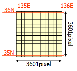
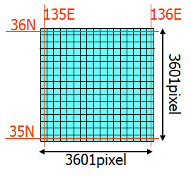
| File Name(Example of N35~36,E135~136) |
ASTWBDV001_N35E135_dem.tif |
ASTWBDV001_N35E135_att.tif |
| Elevation of waterbody |
Classification of waterbody |
 |
 |
| Output format |
GeoTIFF, signed 16 bits |
GeoTIFF, unsigned 8 bits |
| Geographic coordinates |
Geographic latitude and longitude |
| Tile Size |
3601-by-3601 pixels (1-by-1 degree) |
| Posting interval |
1 arc-second |
| DN values |
1m/DN referenced to the WGS84/EGM96 geoid-9999 for land and void pixels, and 0 for sea water body |
Land:0, Sea:1, River:2, Lake:3 |
| Coverage |
North 83 degrees to south 83 degrees, 22,886 tiles
(1-by-1 degree) without tile shows ocean area |
*The detail is described in User Guide.
|
|