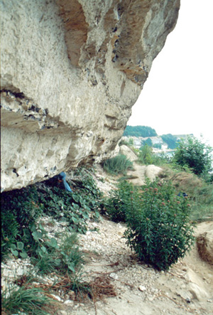
A flat cropland of a few scores of meters above sea levels suddenly meets sea beyond a precipice, which appears as if the land was cut out of the blue. Sea surges at the foot of the precipice. The precipice here keeps record of the major calamity of the earth.
|
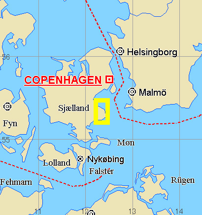
Jutland protruding toward Scandinavian Peninsula and other nearby islands belong to Denmark. Its capital, Copenhagen is located on Sjaelland, a big island located to the east of Jutlnd. A few hours' drive to the south of Copenhagen takes you to seashore called Stevns Klint. It is a minor tour spot, where people visits from time to time. There is nothing but a small church, a small museum and a restaurant there. It was summer, in July 2000 that I visited Stevns Klint. During my stay of two days, I only encountered children coming on a school bus. Some enjoyed walking around the place, while others enjoyed playing at the narrow seashore descending a stair installed at the precipice but nobody was swimming in the sea. It was partly because the shore was rocky and unsuitable for swimming, but more than anything else, it was too cold. A couple of divers I barely found in seawater were apparently shivering from cold. Why should I visit all the way from Japan to such an unpopular place? A faded sign stood on top of the stair tells the reason. It is where KT boundary exists. KT boundary was formed in-between geologic time, Cretaceous and Tertiary, or Mesozoic and Cenozoic. KT boundary formation coincided with the extinction of dinosaur. It can be found in many other places on earth but the one in Stevns Klint is the most clear and easy to be recognized by everyone. Since stratums above and below KT boundary consist of whitish rocks called chalk, KT boundary, which is composed black clay, stands out clearly. Originally, chalk for blackboard was made of the rock, but recently, industrial materials are used for the production. Chalk is called Hakua in Japanese, which means Cretaceous. Calcareous rock is formed at the sea bottom when microbes such as foraminifers and nannoplankton are dead and accumulated. Chalk is thus formed at the bottom of warm seas. Precipices of chalk can also be found in the North American Continent and European coasts facing the Atlantic Ocean. It is quite strange that sediments of the age boundary are so different from those of bordering ages. It means that although the ocean at the end of Cretaceous and in the beginning of Tertiary was warm, the environment in the age boundary was completely different, which caused completely different sediments to deposit. And the environmental change drove dinosaurs to extinct. What can cause such sea change to the earth's environment? Generally speaking, environmental change is caused by the climate change such as global scaled cooling or warming and continental drift or topographical change due to plate tectonics and other factors. However, it takes tens of thousands of years for such changes to take place. Even if extinction of massive creatures accompanied in the process, some species could have found a way for survival by evolving to adapt to the changing environment. This was not the case with the extinction occurred in Cretaceous, when massive creatures disappeared all of a sudden, not allowing them a time for evolution to take place. It might as well be called a calamity, rather than a change. A meteorite collision is considered to have triggered the calamity. It is said that a meteorite of about 10km of diameter was collided in Yucatan Peninsula in Central America. Various scenarios are considered for the process but the essence is as follows: Immediately after the collision of meteorite, intense impulse waves and heat ripped through, just like after a huge explosion. Creatures in the surrounding areas were burnt to death. The real problem was the aftermath of the collision. Following colossal tsunami and huge amount of dust and soot, which went up in the air, generated enormous calamity of an unimaginable degree to human beings. All the low land areas in the world were washed away by the tsunami, but above anything else, dust and soot up in the air reached as high as the stratosphere and did not fall on a ground for many years, shutting out sunlight reaching ground. Photosynthetic plants died out, herbivorous animals starved to death, and carnivorous animals also starved to death. Even microorganisms, which decompose dead animals died out. In other words, the total ecological system on earth collapsed, not to mention large animals like dinosaurs but even microorganisms in the sea received the influence. This is the big calamity recorded to the clay stratum in-between chalk stratums. Clay stratum was formed because creatures in sea, which accumulate at the sea bottom after death and form chalk, extinguished. Components of clay stratum are also mixed in chalk stratum, but due to the suspension of the accumulation of chalk, they concentrated as a clay stratum. As the study on KT stratums in the world progresses, it became clear that particles originating in meteorites, iridium which is hardly contained in rocks on earth but abundant in meteorites, crushed minerals and scattered soot are contained in the stratum, providing evidences to endorse the collision theory. To one's surprise, certain organisms survived the calamity. Those are the ancestor of mammals including human being and the microorganisms that formed chalk above KT boundary. Organisms have both strong side and weak side. When faced with a certain severe environment, those that cannot resist it disappear but those that survived enjoy prosperity afterwards. In Neozoic, mammals prospered greatly, culminating in the birth of human beings that are intelligent enough to challenge the mystery of KT boundary. The sign stood in the seashore of Stevns Klint said it is the place of KT boundary and in the nearby small museum, explanation about KT boundary was provided. While watching people visiting the small church and children playing on the boundary of land and sea, I thought about the boundary of ages. 2003. November 1st
|
|
|
|
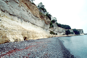
Picture - 1 The precipice of chalk Precipice in Stevns Klint in Denmark is white. Narrow seashore appears during an ebb tide. The reason that the land of chalk forms precipice all along the coast like the one in the picture is that chalk easily dissolves in water and thus susceptible to erosion. Erosion of the coastline is ongoing and it will continue in the future too. Since stones of the seashore are also chalk, they dissolve in water easily, thus keeping the size of the seashore narrow. |
 |
Picture - 2 Coastal erosion The precipice became dent by the work of waves. If coastal erosion progresses further, the upper part of the slanted cliff breaks off and forms vertical precipice like the one shown in picture -1. KT boundary exists deep inside the dent, which poses the risk of the cliff to fall off anytime. |
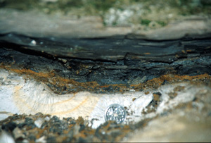 |
Picture - 3 KT boundary, a clay stratum The KT boundary in the picture is a few centimeters thick. Since clay stratum is more susceptible to erosion than chalk stratum, the layer is dent. In addition, at places where easy access to people, traces of scraping the clay stratum were found. The clear contrast of the clay stratum and chalk stratum convinced me of the sudden disappearance of organisms. |
Copyright of Image - 1 belongs to JSS and that of text and Picture - 1 through 3 belongs to Prof. Yoshiyuki Koide of Sapporo Gakuin University. Permission of JSS is required of their use for other purposes.