An endless highway along a cobalt blue ocean. It is easy to imagine how comfortable driving such a highway would be, even for those who do not especially like driving. Zipping through clear blue sky and ocean was as if you are drawing the horizon. The highway over ocean also opened my eyes toward another world of land formation.
|
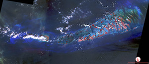
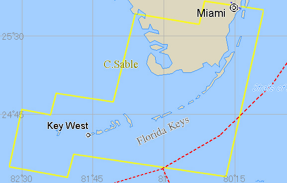
Since I like visiting national parks in the US, I make it to visit one whenever I have a chance to go to the US. In April 1996, I visited NASA Kennedy Space Center in Cape Canaveral, in Florida Peninsula. In that occasion, I went to Everglades National Park and Biscayne National Park located in southern part of the peninsula. I also spared one day to explore further down to Key West. U.S. Highway Route 1 is extended from Florida peninsula all the way to Key West, an island at the southern tip of the country, connecting a stitch of islands called Florida Keys on the way. In the middle of Florida Keys, there is a town called Marathon. 7 miles bridge, which often appears on screen or TV commercials, is located to south from the town. Since 7 miles bridge has slopes going up and down as well as curves, driving along it is quite exiting as if you are driving above ocean. Route 1 terminates at Key West, where there is Southern Most Point. However, actually, US army base is located to the south beyond the point and other U.S. islands do exist to the south of Key West. Key West is only 150km away from Cuba and I heard a lot of people speaking in Spanish there, which is quite an unfamiliar language to me. A great writer, Earnest Hemingway loved Key West, and he spent 8 years there with his family. The house where he used to live is reserved as a museum. Florida peninsula is a wetland. Environment of wetland is diverse, for example, a round and small hill with trees exists in the middle of marshy plants, the small forest is like an island surrounded by an ocean. The wildlife peculiar to wetland inhabits the wetland. Of all the wildlife I encountered in the peninsula, an alligator was the most striking. In a flat wetland like Florida Keys, finding rocks and stratum is often difficult. However, at a roadside construction site, I peered in a hole made for setting a telegraph pole and happened to find a rock, which was composed sorely of shells. It would be more appropriate to call it a chunk of rubble rather than a rock, because it seemed easily crush into pieces when firmly gripped. Also, I found a number of gravels made of coral skeleton in mangroves and at seashores in Florida Keys. Since the sea from Florida Peninsula all through Florida Keys are shallow and there is no big rivers that works to carry sediments, shells and corals are the main component of rocks in the area. It was somewhat a strange experience to me, who is accustomed to watching sedimentary rocks, composed of earth and sand. I live on the Japanese Archipelago, a volcanic belt with humid temperate climate. In such an environment, earth and sand eroded out of volcanic rocks and mountains by rivers accumulate in seabed. Accumulated sediments form sedimentary rocks over time. The Japanese Archipelago has been formed after repeated and ongoing sedimentary rock formations and their elevation. This is the reason why Japanese people commonly think of sand and earth as the primary component of rocks. But it is a preconceived notion. Definition of sedimentary rocks in Japan is too narrow and limited. Rocks in Florida Keys made me recognize that the world is large and diverse. There is one more thing that Florida Keys taught me during the trip. The word "key" used for Florida Keys or Key West originates in Spanish word cayo, meaning coral reef. From Biscayne Bay in northeast to Key West in southwest, Florida Keys is composed of a chain of islands surrounded by coral reefs stretching as long as 200km in distance. Since coral reefs grow in shoal, the crescent-shaped archipelago is formed in shoal from the beginning, not in the middle of a deep ocean. You can see the fact well in a satellite image or a bathymetric chart. The shoal stretching from Florida Peninsula is extended throughout Florida Keys. In other words, although the land of Florida Keys is only partially above sea surface as islands, you can see that those islands are connected, consisting part of the American continent below the sea surface if you look at a bathymetric chart. Elevation of land in Florida Peninsula and Florida Keys coincided, and continent became a humid temperate zone, while element of sea worked stronger for the latter and formed islands of coral reefs. The chain of islands had originally been bridged down in water before people builds a highway above the sea. The former highway is by far the larger than the latter. When it comes to creating something, power of nature seems to be incomparable to that of human beings. Florida Keys is a tail of continent stretching out into an ocean. People have access to the tip of the tail through a thin manmade thread, a highway. Although it may be one of the trivial ambitions of human beings to reach edges of the world, I could enjoy comfortable breeze and recognize the immensity of the earth, thanks to it. 2003. Oct. 1st
|
|
|
|
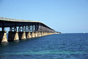
Picture - 1 Outreaching highway above ocean Even a little mistake behind the wheel on the highway leads to a fatal accident, but driving here was refreshing and pleasant enough to brave the fear. |
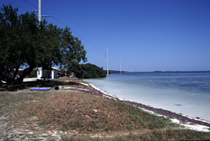 |
Picture - 2 Blue ocean and white shore The picture shows one of the typical resorts on a tropical island. Squall is inevitable in tropics. When one is caught in it, there is nothing he or she can do but wait until the intensive downpour passes and strong sunlight comes back. |
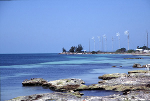 |
Picture - 3 What lies over the blue ocean? Southern Most Point is located over the ocean. But it represents the southernmost point accessible by the general people. U.S. army base is located in the actual southernmost point of the U.S. Existence of the base reminded me of once tense relationship between the U.S. and Cuba. Those who live in Key West were sunny, Spanish speaking people, apart from the historical crisis at the border. |
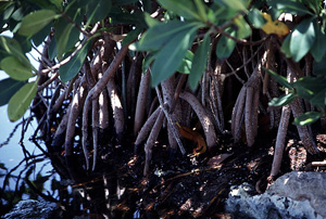 |
Picture - 4 Mangrove Green vegetations on Florida Keys islands are the ones typical in the coastal area of tropics, such as mangrove. Mangrove grows in Okinawa in Japan too. It is a strong plant defying salty water. |
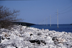 |
Picture - 5 Reef rocks I found a lot of coral skeletons in a seashore, which made me recognize that the island is a coral island. |
|
|
Picture - 6 Coral The rock exhibits a pattern of coral well. It was used as a local monument. I liked the monument because it truly came from the island, directly reflecting the local feature. |
Copyright of Image - 1 and 2 belongs to JSS and that of text and Picture - 1 through 6 belongs to Prof. Yoshiyuki Koide of Sapporo Gakuin University. Permission of JSS is required of their use for other purposes.
