
Greenland, that's the place I had long wanted to visit ever since I set my mind to be a geologist. The other day, I finally paid a visit to Greenland only for a short time. However, I fully appreciated the land filled with ice and rocks.
|
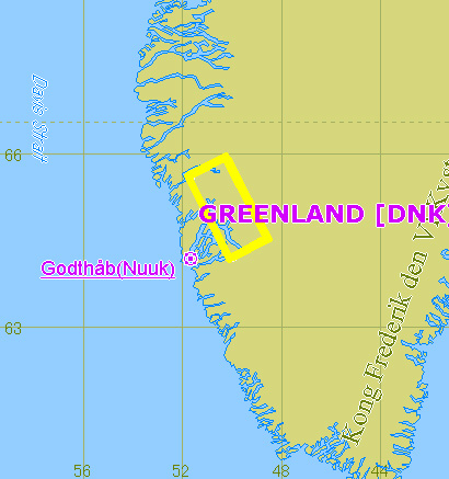
Greenland is too large to be called an island. I would rather call it a white continent. The island is called green-land, not even white-land. One might think of Greenland as an island filled with snow and ice, which keeps people away, but the place has been inhibited by Inuit (called Greenlandic locally) for a long time. Inuit used to make their living by fishing and hunting, inhabiting on a shorefront. However, by the policy of the government, they are being transferred to city areas for settlement. Since Greenland is the territory of the Kingdom of Denmark, white population from the mainland dominates the city area. However, due to lack of jobs during a long and severe winter, not many people permanently dwell in Greenland. They come to the island mainly during summer seasons. Geologists are no exception to that. In summer, geologists come to Greenland from all over the world for study. Among geologists, Greenland is a famous place for having various oldest rocks on earth, represented by sedimentary rock. Amongst others, the fact that rocks of 3.8 billion years ago exist in a place called Isua is quite famous. However, not many geologists can actually visit Isua. The record of the world's oldest rock in Isua was broken by the rock discovered in Canada ten years ago and the record of oldest mineral in Isua was broken by Australia. But the record of the world's oldest sedimentary rock in Isua is yet to be broken. The world's oldest accretionary prism and oceanic crust were also discovered in other areas of Greenland. Geologists are deeply committed in finding the oldest thing on earth because there is a good reason for that. When earth was created, thick and hot molten lava covered the surface. Making assumption of the age of the oldest rock on earth leads to know when the molten lava was solidified. So far, the mineral occurred 4,276 million years ago in Australia is recognized as the oldest one on earth. Still, Greenland provides a lot of meaningful sources of research for geologists to elucidate the history of earth. As the earth cooled down, H2O existed in the atmosphere had been liquefied and fell on earth as rain according to the rule of gravity. Drops of rain formed a stream of river and pooled to the bottom of lower ground, which is the origin of an ocean. Sedimentary rocks occur by the accumulation of sediments carried into an ocean via a river. The oldest sedimentary rocks in earth's history tells us when earth temperature became cold enough to allow for the existence of liquid H2O, in other words, led to the formation of an ocean. The fact that the world's oldest sedimentary rock exists in Greenland indicates that the ocean there is the world's oldest. Temperature of earth had been gradually cooled down to the point of zero degrees Celsius. The fact that sedimentary rocks have been formed in various ages since 3.8 billion years ago in various parts of the world, indicates that the flow of water never ceased on a global scale, in other words, the overall temperature of earth did not fall below zero, nor above 100 degrees Celsius. Isua is located at N65.12degree and W49.98degree, southwestern part of Greenland across the border between ice sheets and bare rocks. People do not live in Isua, where cold wind coming from iceberg blows and you cannot stay outside long without a winter jacket even in summer. I visited Isua in summer of 2000. I planned to stay for 10 days in Greenland, of which I spent 6 days in the biggest city in Greenland, Nuuk (Godthab) then, I chartered a helicopter to go to Isua. Thanks to the good weather condition, the helicopter flew on schedule and I was able to land on Isua. I planned to spend 5 hours in Isua except for three hours' flight but due to the dense fog in the way, I had to spend an hour waiting at a valley until the sky cleared. When I finally arrived at Isua, I was surprised to find a several tents put up in such a bleak remote place from town. Tent city like this appears in summer as a base for geologists coming from anywhere in the world. I happened to meet a famous geologist from Denmark, Dr. Apel, who was acting as a leader of the tent group. Although I knew him by name, I did not expect he had stayed in Greenland. Otherwise, I could have contacted him in advance. He advised me to stay at Isua for a few days if I wanted to observe the rocks there well, but it was all too late. Nevertheless, he guided me during my stay in Isua and I could efficiently look around the rocks that I wanted to observe and collect samples in a short time. Except for the research, the purpose of my visit to Greenland was to feel something in the atmosphere. I wanted to physically feel geologically valuable rocks exposing myself in wind, temperature and smell of the land, and memorize the impression. Time I spent in Isua was only three hours all in all, which is too short to call it a research and I must have missed an opportunity to explore the greater part of geological values there. Nevertheless, I am satisfied with the visit because I could observe the rocks in Isua with my eyes and hands in the nature which had fostered them. It is the most impressive of all the places I have visited as part of my geological study. I will never forget the atmosphere I felt there for the rest of my life. 2003. Sep. 1st
|
|
|
|
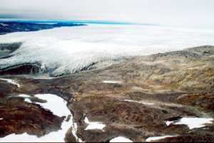
Picture - 1 Border between ice sheet and bare rocks Isua is located across a border between ice sheet and bare rocks. In summer, the ice melts and forms a pond, which provides source of water for geologists visiting the area. Such a bleak place can be a land of dream for geologists. |
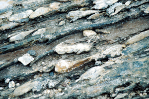 |
Picture - 2 The oldest sedimentary rock in the world Sedimentary rocks, which is composed of conglomerate and sandstone consists the world's oldest stratum. It indicates that the ocean where the stratum exists is the world's oldest. In some parts of the stratum, I found a lot of garnets occurred due to metamorphism. Before, the conglomerate is considered to have generated in a shore, but now it is considered to have occurred due to an avalanche of sand and rocks accumulated on the sea trench. |
 |
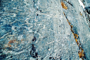
Picture - 3 Banded iron formation On top of the stratum, banded iron formation lies. This is the world's oldest banded iron formation considered to have occurred inorganically, but not much is known about it. Although banded iron formation formed 2 billion years ago is known to have occurred due to oxygen, it is unknown why the formation occurred 3.8 billion years ago, long before the appearance of oxygen on earth. |
 |
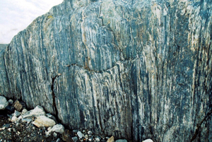
Picture - 4 Pillow lava Numerous ellipse circles in white can be seen on the rock surface. This is the world's oldest pillow lava. If basalt molten lava erupts in water, pillow shaped rocks pile up. This is the cross section of pillow lava exposed due to erosion by glacier. Sea bottom is covered with pillow lava like this. Pillow lava in the picture indicates that the place where it lies was once at the bottom of a sea, which came into existence for the first time in earth's history. |
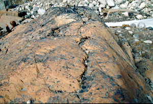 |
Picture - 5 Peridotite Peridotite is a rock which consists mantle. Mantle lies at the bottom of oceanic crust. Sometimes, oceanic crust and mantle are elevated together above the ground surface. Types of rocks which formerly consisted a part of oceanic plate are called ophiolite. The world's oldest ophiolite exists in Greenland. |
|
|
Picture - 6 A whale There is a high possibility of encountering a whale in the sea surrounding Greenland. I have joined a whale watching tour and encountered a lot of whales. Their dynamic swim was quite impressive. |
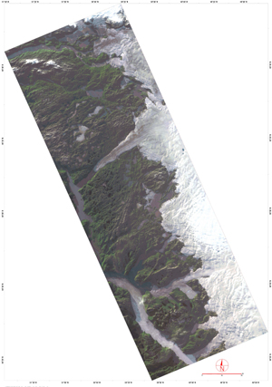
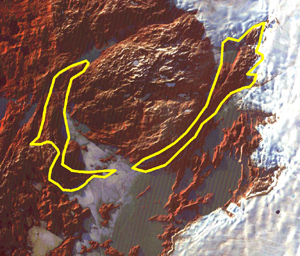
Copyright of Image - 1 and 2 belongs to JSS and that of text and Picture - 1 through 6 belongs to Prof. Yoshiyuki Koide of Sapporo Gakuin University. Permission of JSS is required to their use for other purposes.