
A volcanic eruption is depicted in some American movies such as "Volcano", "Dante's Peak" and "Volcano Inferno", which were also released in Japan. Although there were some scenes scientifically incorrect, these movies contributed to propagate threat and danger associated with a volcano.
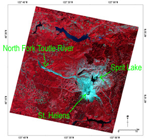
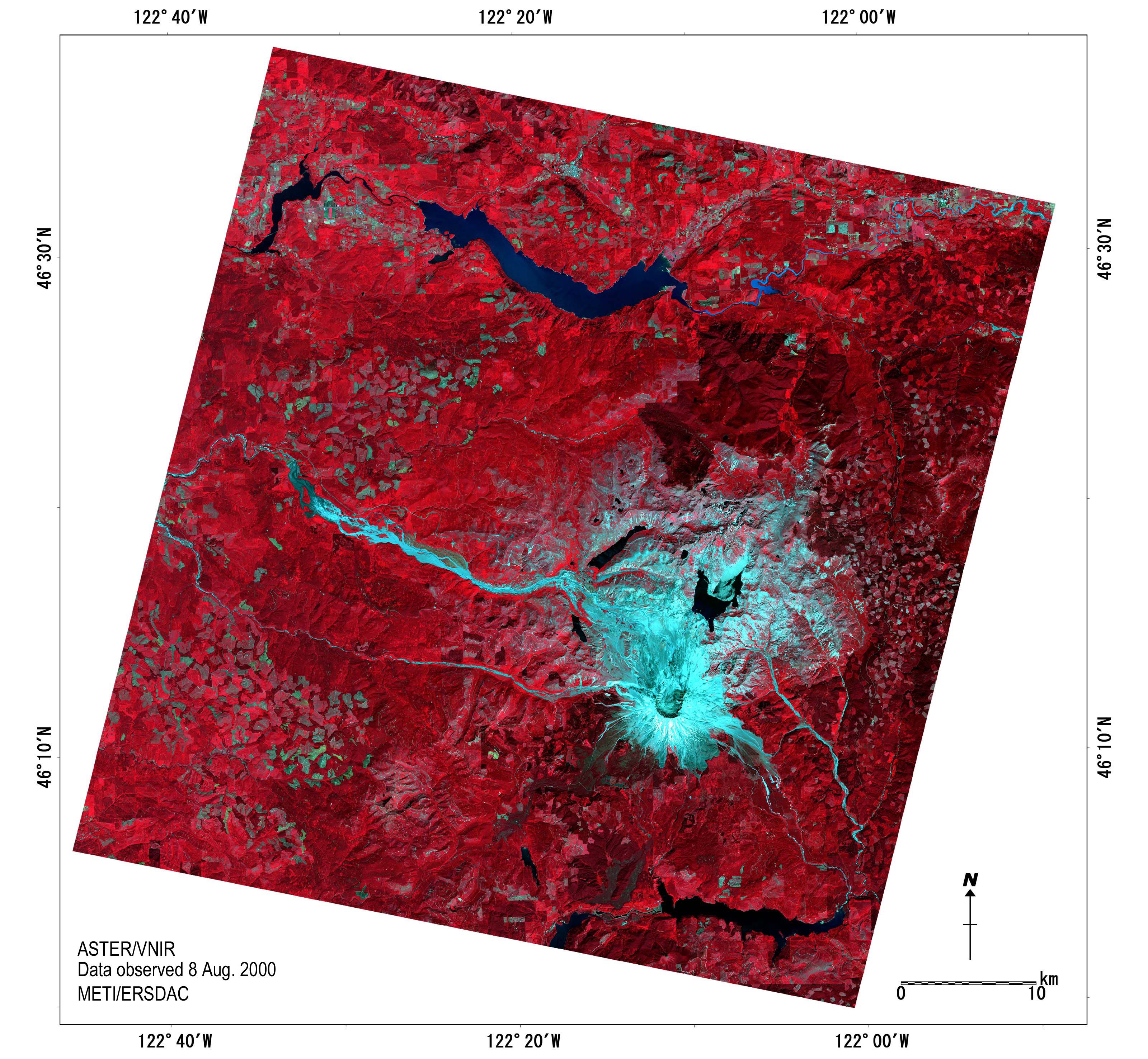
Figure - 1 False color image of St. Helens (Terra/ASTER observed on 8 August 2000. RGB=band 3,2,1)
In the image, water appears in black, vegetation in red and bare ground surface in light blue. Effect of the eruption can be seen in light blue color. The image shows horseshoe caldera open to the north, mudflows from the crater (seen in gray zone spread from north to northwest of the volcano) and sediments in the rivers such as North Fork Turtle River (seen in light blue).
For enlargement (jpeg file of 2.5MB)
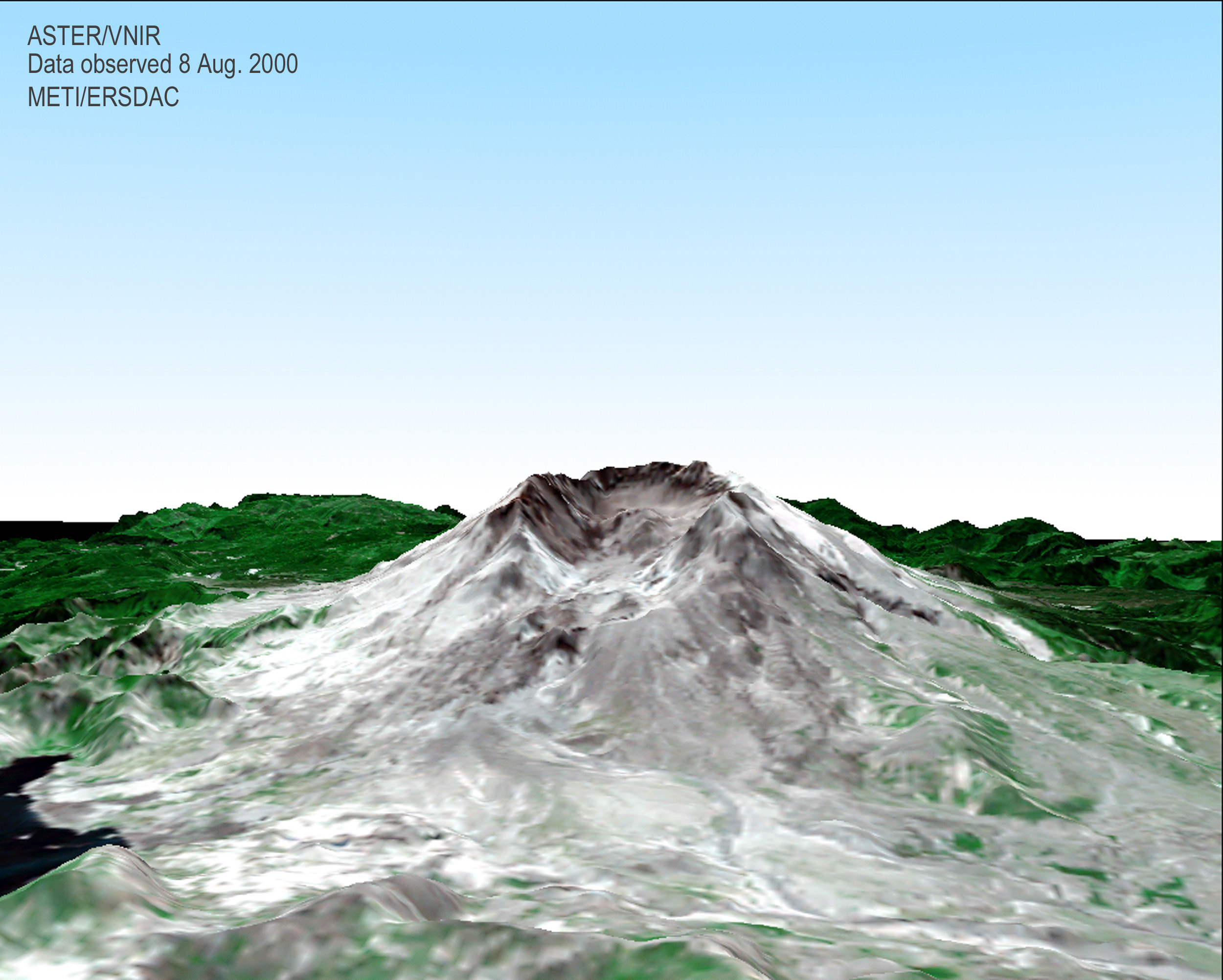
Figure - 2 Bird's eye view of St. Helens (VNIR and DEM data of Terra/ASTER observed on 8 August 2000. RGB=band2, (band1*3+band3)/4, band1)
For enlargement (jpeg file of 1.0MB)
This is bird's eye view image produced from Terra/ASTER data. This image shows St. Helens seen from north (same direction as Figure - 4(a)). In the image, water appears in black, vegetation in green and ground surface without vegetation in white and gray. The image shows a lava dome inside the crater and mudflows.
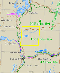
Figure - 3 Location of the image on a map
Although it may not be widely recognized, the U.S. is a volcanic country with a lot of earthquakes. Volcanoes in Hawaii, a big earthquake in Los Angels, San Andreas Fault and geysers in Yellow Stone National Park are just a few examples among 65 active volcanoes acknowledged in the U.S. (In case of Japan, there are 102 active volcanoes according to Japanese Coordinating Committee for Prediction of Volcanic Eruption.)
Especially, Cascades in Washington State located near pacific coast is one of the largest volcanic belts in the U.S. The eruption of St. Helens in northern part of Cascades is still fresh in our memory.
The severe phreatic eruption of St. Helens occurred at 8:23 in 18 March 1980, along with an earthquake of magnitude 5.0.
North side of the mountain disappeared instantly deforming the mountaintop into a horseshoe caldera. Blasts of the eruption reached 28km away from the mountaintop, destroying a forest of 600 sq km located in the north. Volcanic ash of the eruption reached up to stratosphere.
Heat of the eruption melted snow and ice, which ran down North Fork Turtle River turning into mudflows and formed a stratum of 20m thick at the mountain foot.
Ever since the first eruption, St. Helens has repeated formation and breakdown of its lava dome for more than 12 times along with pyroclastic flows until it puts an end to the series of volcanic activities in 1986. As a result, a lava dome of 1km diameter and 260m high was formed inside the horseshoe caldera.
Lives of 57 people were lost in times of the eruption in 1980. The victims include David A. Johnston of U.S. Geological Survey, who was killed in the middle of observation of the volcano. Johnston Observation Center was built in the place of his death as a museum open to public. Why so many people have been killed in the eruption?
St. Helens has been acknowledged as an active volcano since before the eruption. U.S. Geological Survey found out in 1970's that St. Helens was the most active volcano in Cascades. It was also known that the movement that formed a dacitic lava dome consisted of dacite occurred at least three times in the last 600 years. In times of the eruption in 1857, andesitic lava flew out of Goat Rock located in the middle of northwestern mountainside.
All these facts provide evidence that St. Helens is an active volcano. Indeed, a possibility of St. Helens eruption was considered quite high and that in the near future (before 2000). Actually, U.S. Geological Survey had predicted some eruptions from 1980 to 1986 quite accurately.
Signs of the eruption had been observed too: volcanic earthquakes since 20 March, two months before the first eruption, and a phreatic eruption from the mountaintop dome on 27 March. Phreatic eruptions had repeated ever since, which caused upheaval of north side of the mountain by 2m everyday until it reaches 100m by 18 May.
In spite of all the forecasts and signs, a lot of people died due to unpredictable factors such as the magnitude of the eruption and the accompanying debris flows.
A large scaled rapid mountain collapse is called earth flow. (For animation of St. Helens earth flow, please visit http://www.nagare.or.jp/mm/99/iizawa/japanese/intro0.htm) A flow of high temperature volcanic ash and mud is called pyroclastic flow or pyroclastic surge. A pyroclastic flow of St. Helens was at 35m/sec, or 126km/h, reached 28km away in less than 10 minutes. Nobody can run away on seeing it even in a car. Victims of Mt. Unzen eruption in Japan in 1991 also died of such a rapid pyroclastic flow.
A mudflow can cause great damages too. Bridges, buildings and lumber carriers were destroyed by mudflows accompanied by the St. Helens eruption. A mudflow occurs when magma and rocks get mixed with water from rivers, ponds, melted snow or ice. It destroys everything on the way sliding down a few score kilometers in a few hours. Mudflows accompanied by the eruption of Mt. Nevado de Ruis volcano of Columbia in 1985 caused victims of 23,000. Mudflows by eruptions of Galeras volcano of Columbia in 1992 and Mt. Usu in Japan in 1978 also took a toll.
I have visited St. Helens in 1999, where I found trees left fallen by the eruption after 20 years. They were leveled to the ground by blast to the opposite direction of the crater. Great many pieces of wood were drifting on the surface of Lake Spirits. The mountain is left untouched because it is designated as a National Volcano Memorial Park. It must be the policy of the government to remind people of the danger of natural phenomenon and lessons learned from them.
Science brings about a lot of benefits, and people living in modern society cannot live without it. However, we shouldn't believe in it blindly. Human beings haven't been able to fully reveal the mystery of natural phenomena such as volcano, earthquake and typhoon. In other words, prediction is not 100% reliable. Sometimes it costs too much to learn lessons from nature. Nature is far beyond human wisdom. St. Helens taught us that we must be humble before nature.
1 February 2003, Yoshiyuki Koide
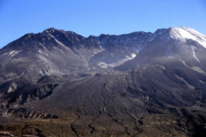
Figure - 4(a) Crater of St. Helens
This is a picture of St. Helens crater seen from north (same direction as Figure - 2). A horseshoe crater of the volcano and a lava dome inside are seen clearly. Water vapor was still coming out of the crater in 1999, seen like a mist in the picture.
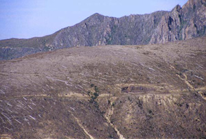
Figure - 4(b) Trees fallen by blast
By the huge eruption on 18 May 1980, trees in the forest of 600 sq km in the north of the volcano were fallen to the direction of blasts. These trees were left untouched to demonstrate the greatness of eruption.
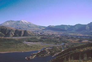
Figure - 4(c) Distance landscape of St. Helens
From the lower reaches of Fork Turtle River flowing from St. Helens, terrain such as pumice-plane, earth flow, dammed lake, and trace of secondary phreatic eruption can be seen.
Copyright of Figure - 1 and 2 belongs to JSS and text and Figure - 4 belongs to Prof. Yoshiyuki Koide of Sapporo Gakuin University. Permission of JSS is needed of their use for other purposes.
