![]()
![]()
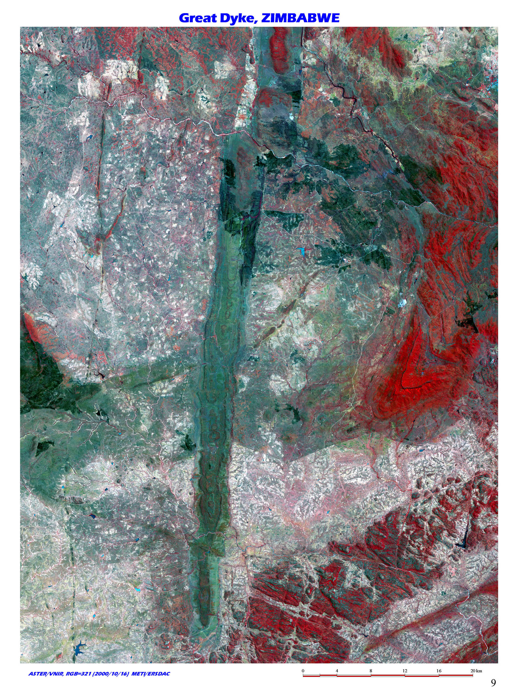 |
1. Great intrusive body with 530km length, The Great Dyke, Zimbabwe / (S20 30/W29 40) The image shows Archeozonic mafic dyke in Zimbabwe (approx. 2.46billion years). The great dyke is 3-12km wide and stretches out 530km from north-northeast to south-southwest, crossing the whole southern Zimbabwe region. The image focuses on 80km at the southern edge. |
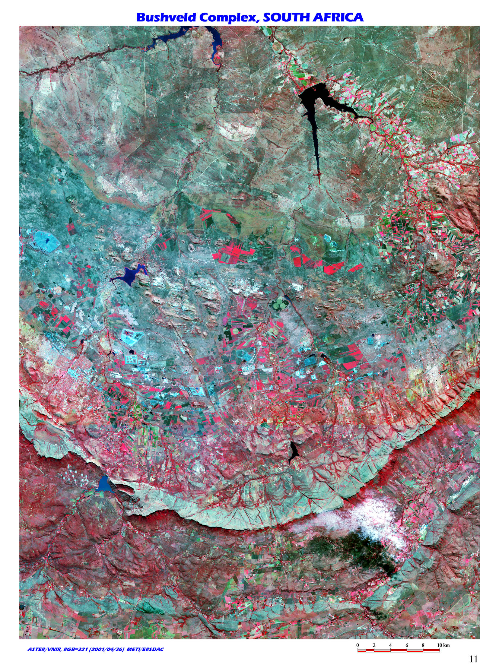 |
2. The world's largest class of igneous bodies, Bushveld Complex, South Africa / (S25 30/E27 30) Bushveld Complex consists of stratiform alkali rock and granite rock intruded upper part of Archeozonic Transvaal system. The complex stretches 480km to east-west and 240km to north-south, comprising one of the largest classes of igneous bodies in the world. |
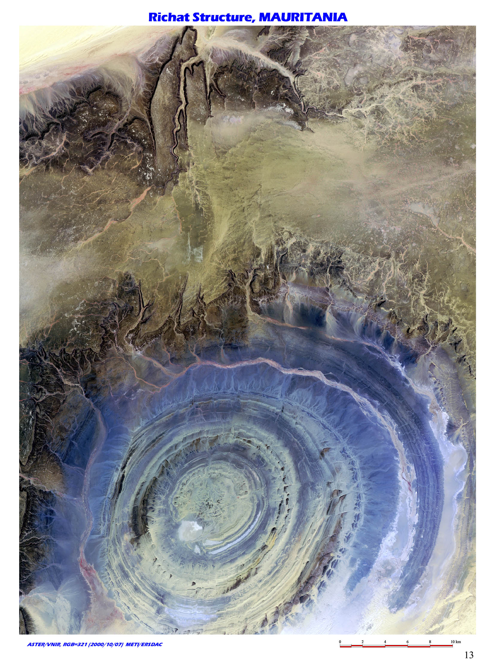 |
3. The huge eye of the earth in the Sahara desert, Richat Structure, Mouritania / (N21 00/W11 20) Located western edge of Sahara desert at central Mauritania in northwest Africa, there is a giant circle called Richat Structure, whose diameter ranges as long as 38km. |
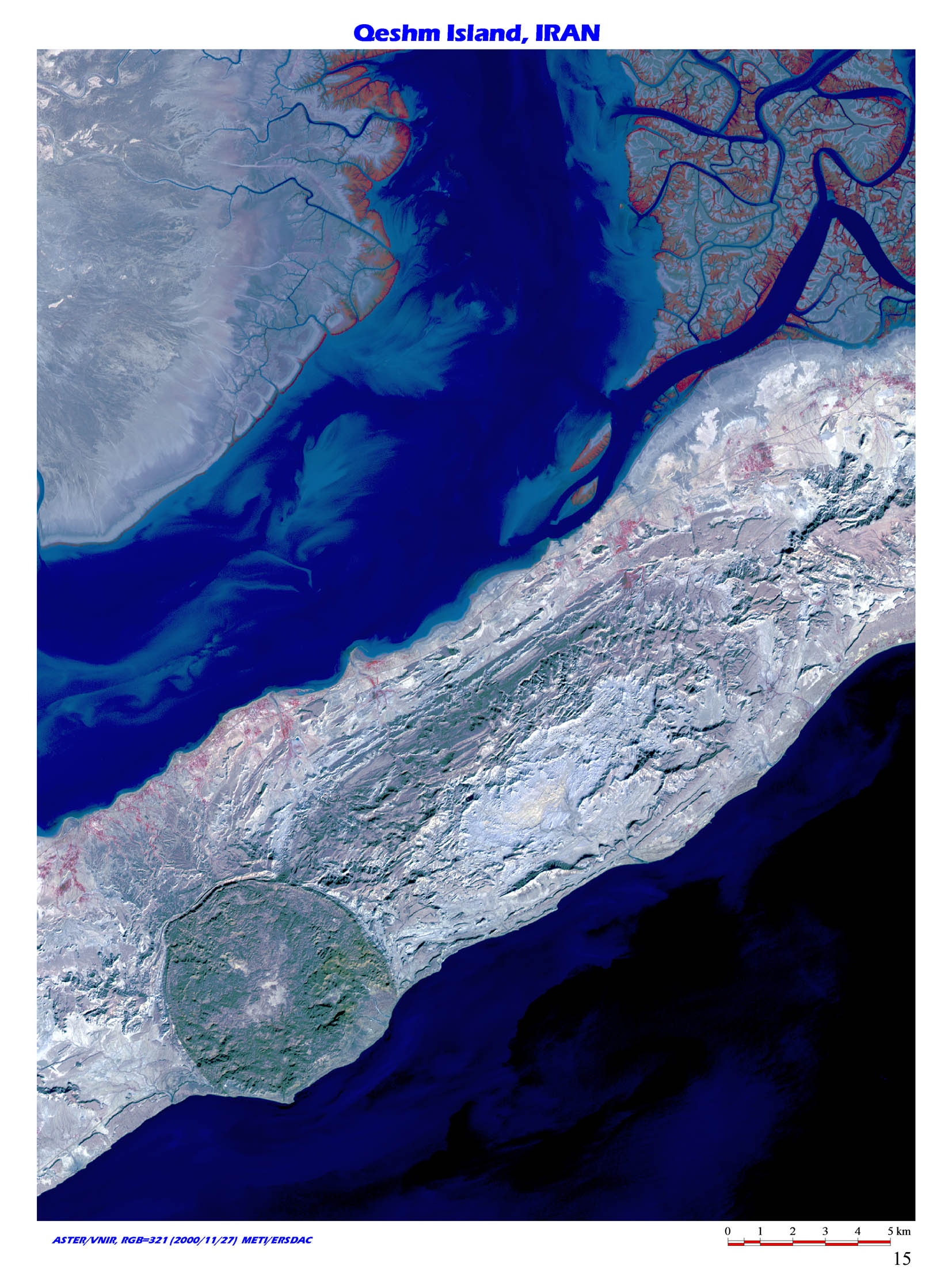 |
4. The great salt dome in the Holmuz straight, Qeshm Island, Iran / (N26 50/E55 30) Qeshm Island floating in Straits of Hormuz at southeastern edge of Iran. Salt dome stands out in the image at lower left. |
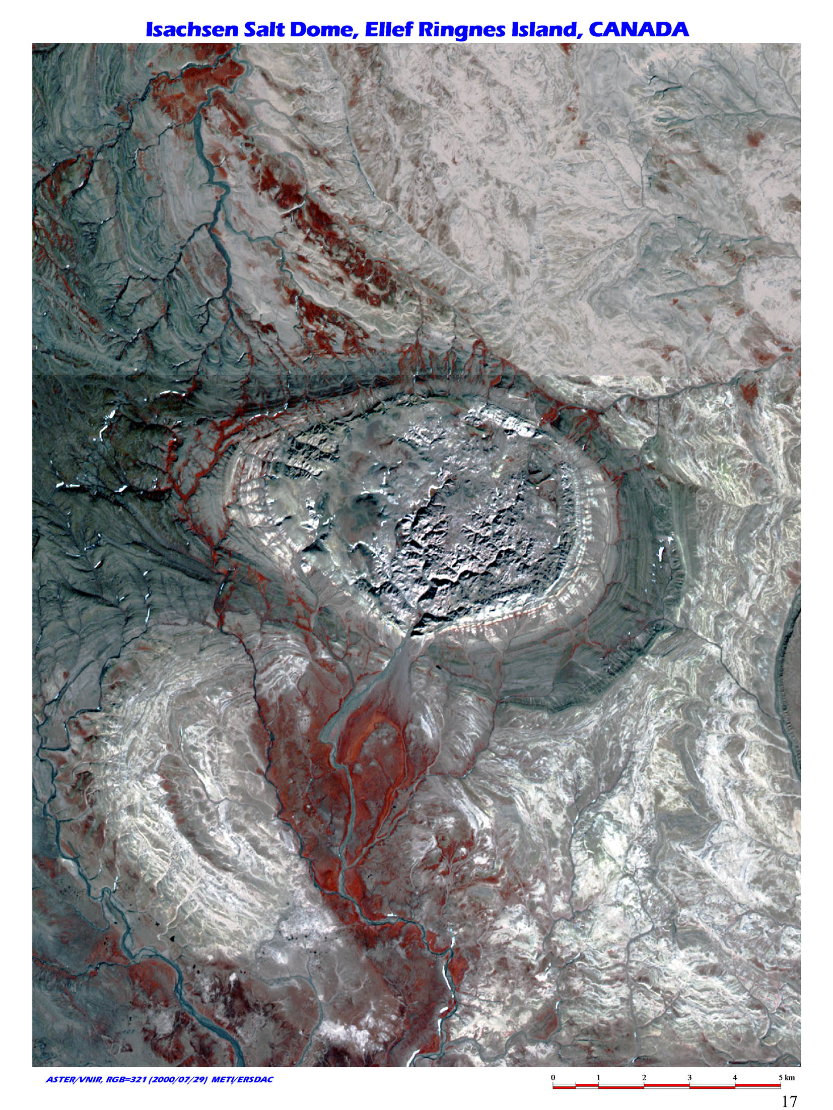 |
5. Salt dome in the Arctic, Isacksen salt dome, Elf Ringnes Isl. NWT, Canada / (N78 40/W101 40) Isacksen salt dome is in Elf Ringnes Island of Queen Elizabeth Islands in NWT, Canada. The dome is 6km in diameter and consists of evaporate formed in late Silurian and intruded in Cretaceous strata. There are some other salt domes around here. These geological feature tells us that quite thick evaporates deposited from late Cambrian to late Silurian. |
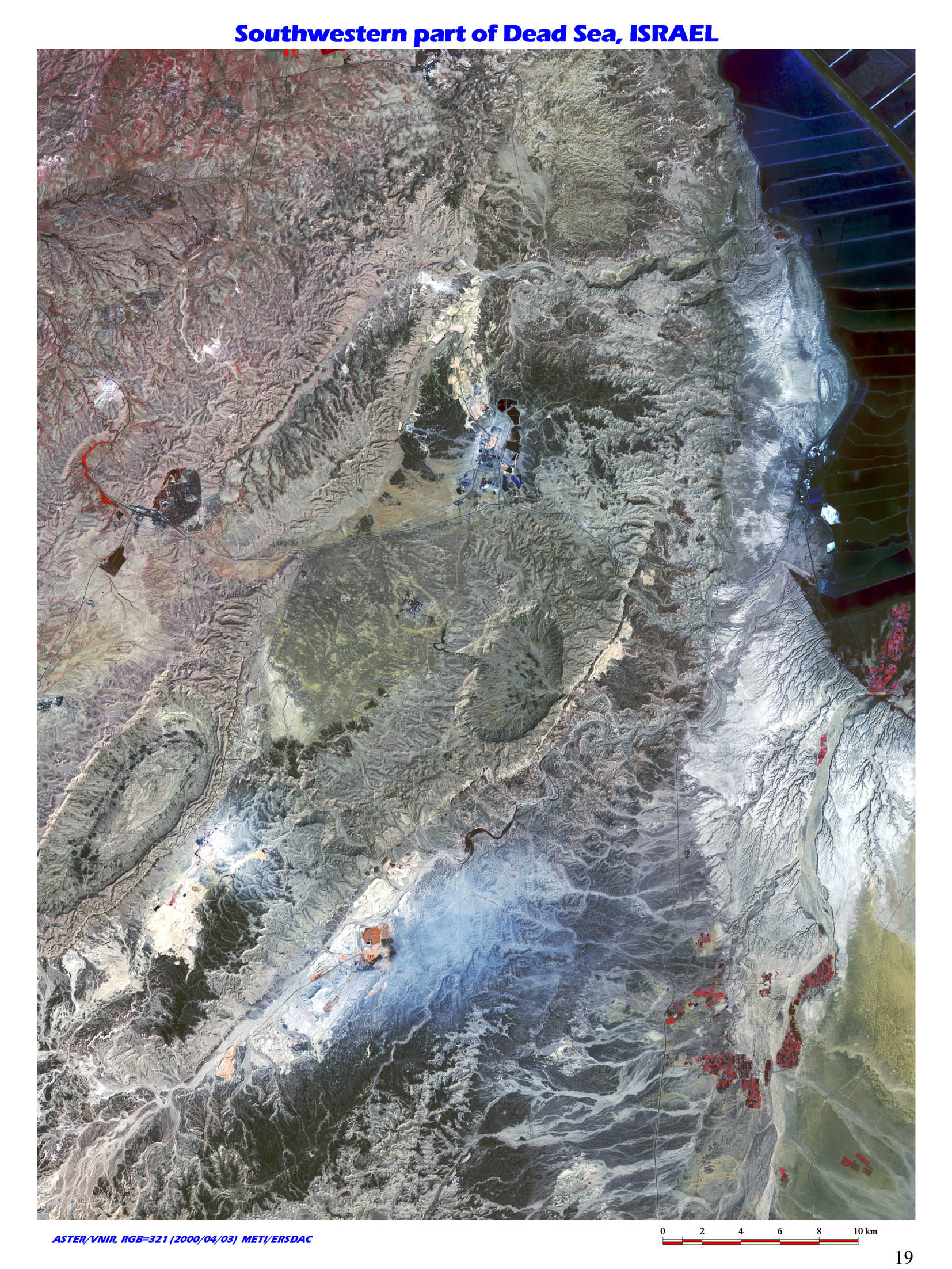 |
6. The world's lowest altitude and highest salinity lake, Dead Sea, Israel / (N31 10/E35 20) Located in the world's lowest altitude, the Dead Sea is a salty lake formed along Dead Sea graben in north-south direction. Water level on the lake surface is _395m and the lake contains 31.5% of salinity, which is 7 ~ 8 times more than that of the average seawater. |
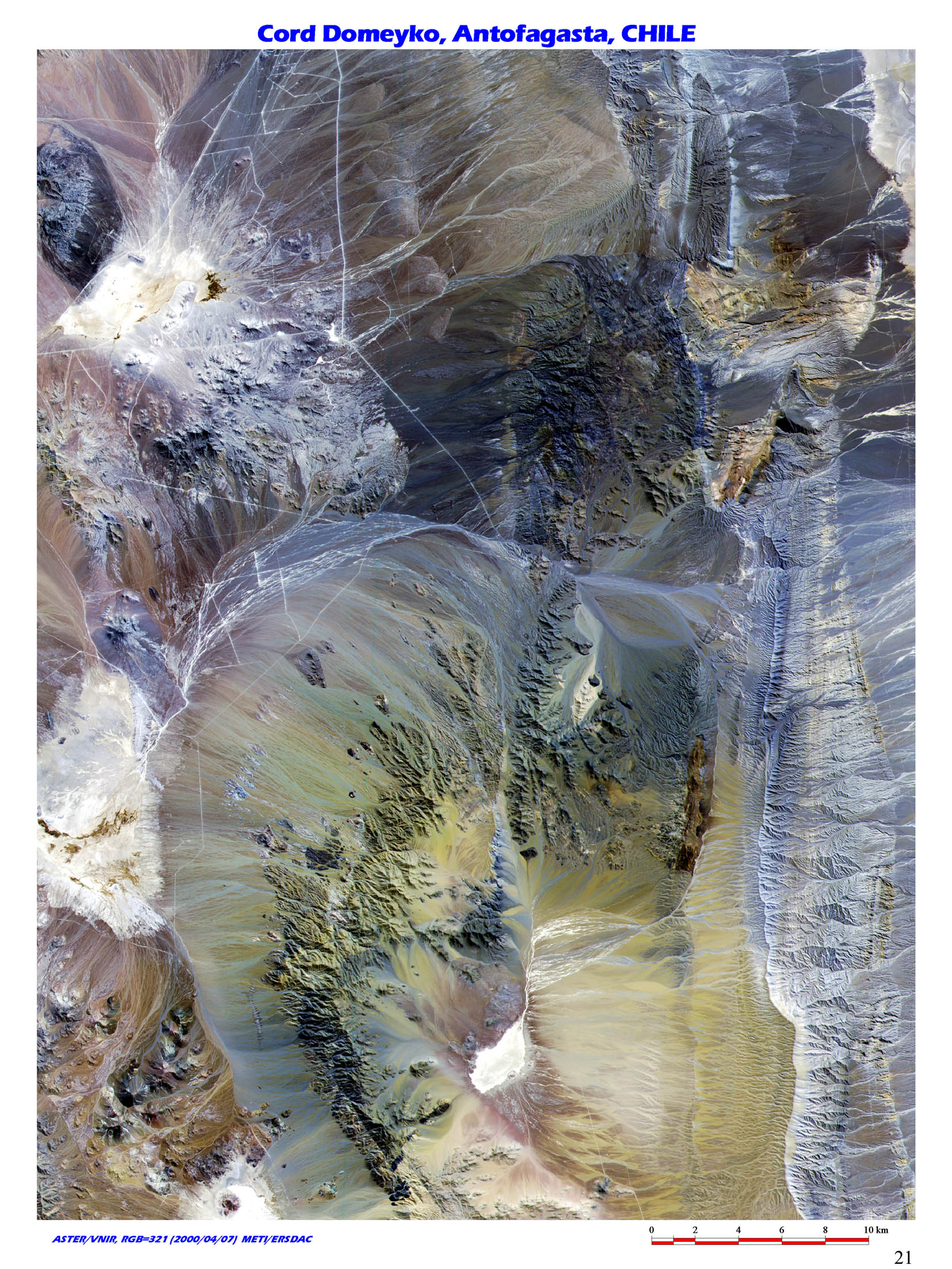 |
7. The world's lowest humidity mountain range, Cord Domeyko, Antofagasta, Chile / (S23 40/W68 50) Cord Domeyko, which stretches Antofagasta in northern Chile is over 3000m high and one of the most dry area in the world. |
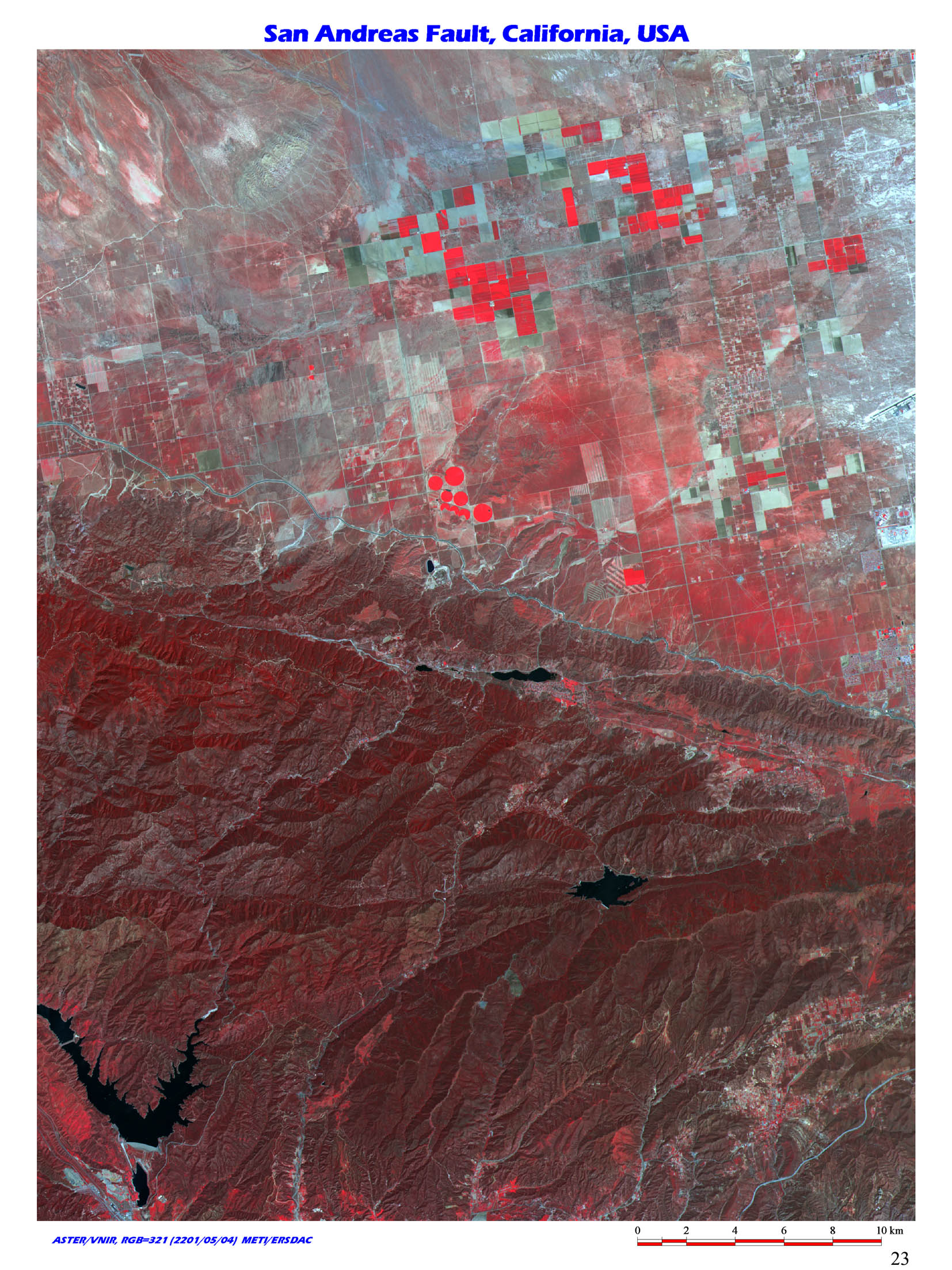 |
8. Transform fault along plate boundary, San Andreas Fault, California, USA / (N34 30/W118 00) San Andreas Fault is great right lateral fault extending from NNW-SSE across California State. |
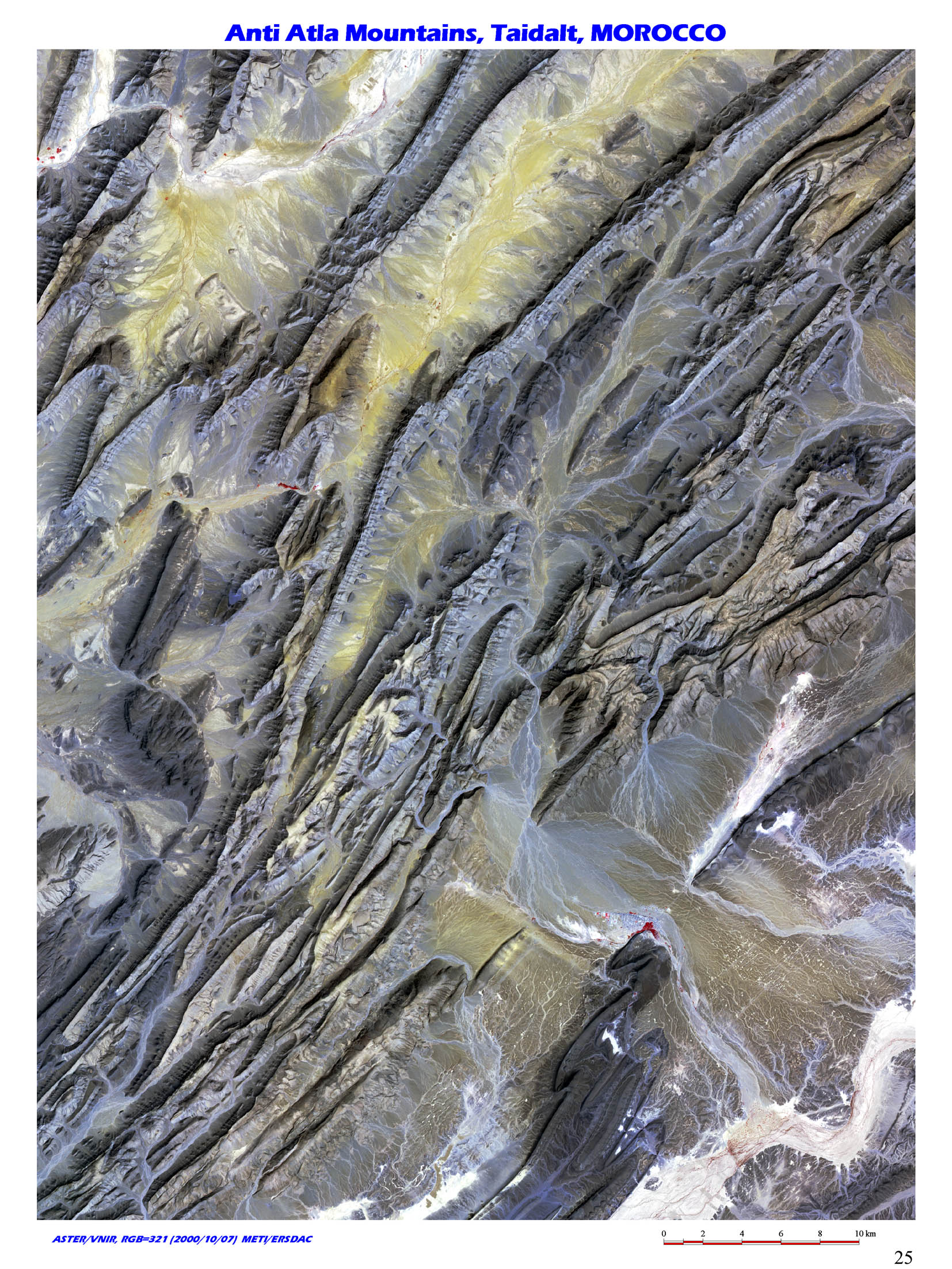 |
9. Fold mountains by the corision of African plate, Anti-Atlas Mountains, Morocco / (N28 45/W09 30) The image is near Taidalt, southern side of Anti-Atlas Mountains in Southwest Morocco. Typical fold Atlas Mountains were formed when Africa and Eurasia continents collided during orogenic movement in Cenozoic and Ththys Sea Closure. Atlas Mountain system is composed of Atlas mountains extending far out to Southern Morocco and Anti-Atlas Mountains of the south side. |
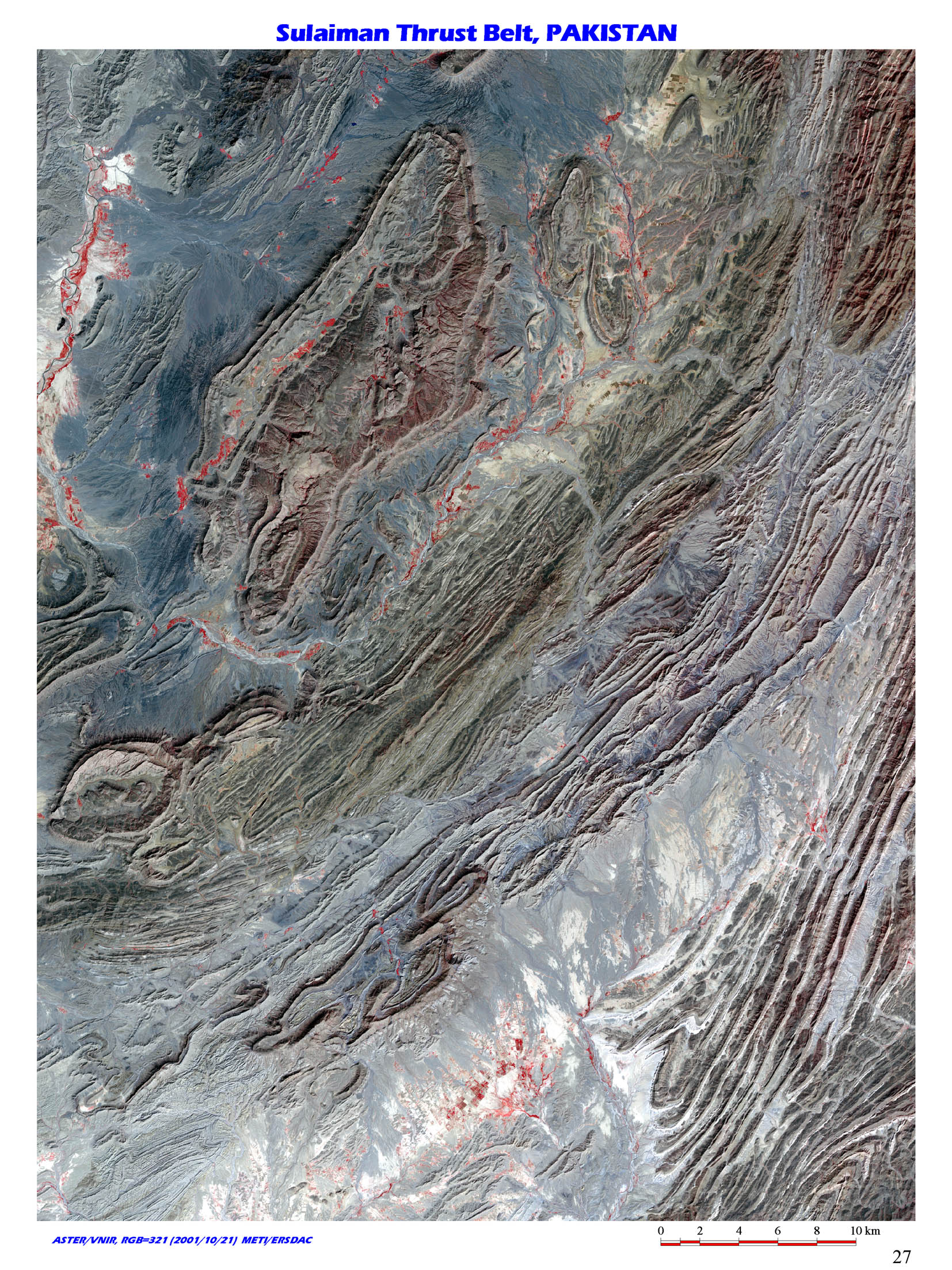 |
10. Fold system by the Indian subcontinent drift, Sulaiman Thrust Belt, Pakistan / (N31 00/E69 30) The image shows Sulaiman Thrust Belt in Central Pakistan. Huge alluvial plain of Indus lies to east and Sulaiman Thrust Belt was formed when Indian sub-continent collided with Eurasian continent and compressed to westward direction. The topographic feature is evident in the image. As one head from north to south along Sulaiman Thrust Belt, younger formations are exposed on the ground surface, and a few thrust sheets developed in the belt, with repeated Palaeogene system and Cretaceous system. |
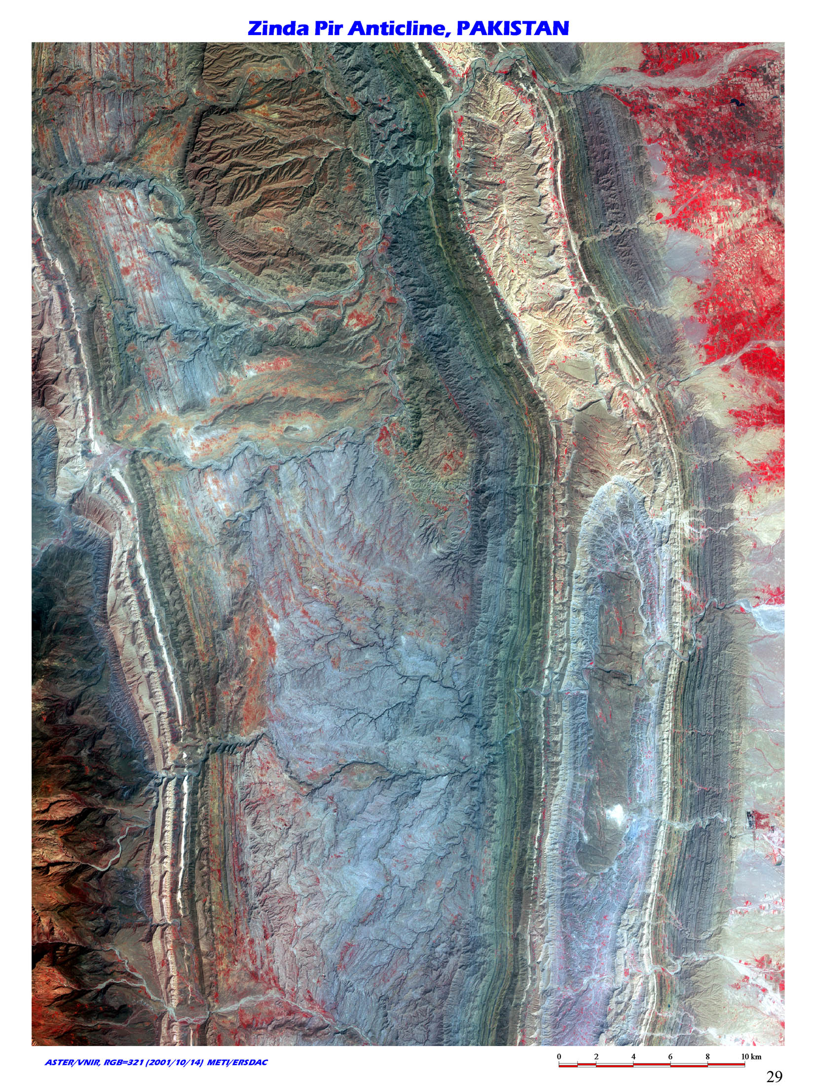 |
11. Anticline structure by the Indian subcontinent drift, Zinda Pia Anticline Structure, Pakistan / (N30 30/E70 20) The image shows anticline of Tertiary rocks in central Pakistan. Along with Sulaiman Thrust Belt (image no. 10), the structure was formed by compression at a time of collision between indian sub-continent and Afghan plate accompanied by the drift of Indian sub-continent to the north direction. |
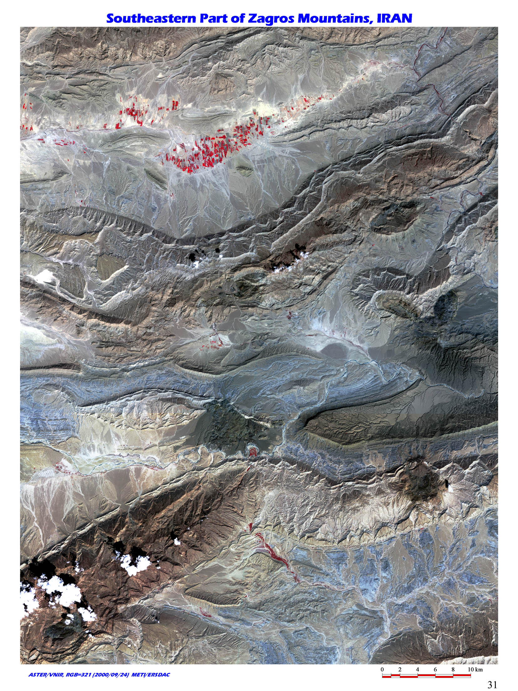 |
12. Anticlinal structure by the Arabian plate drift, Souteastern part of Zagros Mountains, Iran / (N27 40/E55 30) The image shows southeastern part of Zagros Mountain in south Iran. Topographic feature of the area is clear since it hardly nurtures any vegetation. |
 |
13. Anticlinal structure by the Arabian plate drift, Northwestern part of Zagros Mountains, Iran / (N33 50/E47 00) The image shows Sarneh and its surrounding area at the northwest of Zagros Mountains in west Iran, near the border with Iraq. It shows well- developed Zagros fold structure. |
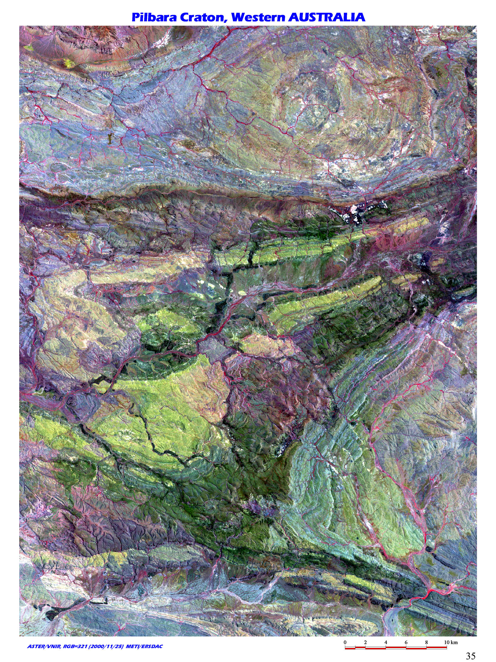 |
14. Huge Iron Formations, Pilbara Craton, Western Australia / (S22 30/E116 45) The image shows Pilbara Craton, stable blocks in Archean distributed in northwest of Australia. Northern area consists of granites and greenstones of approximately 3.6 ~ 2.8 billion years ago in Archean. Southern area is sedimentary basin from Archean to Proterozoic, of which green area called Hamersley group, distinctive with its banded iron formation is the worlds largest iron formation. |
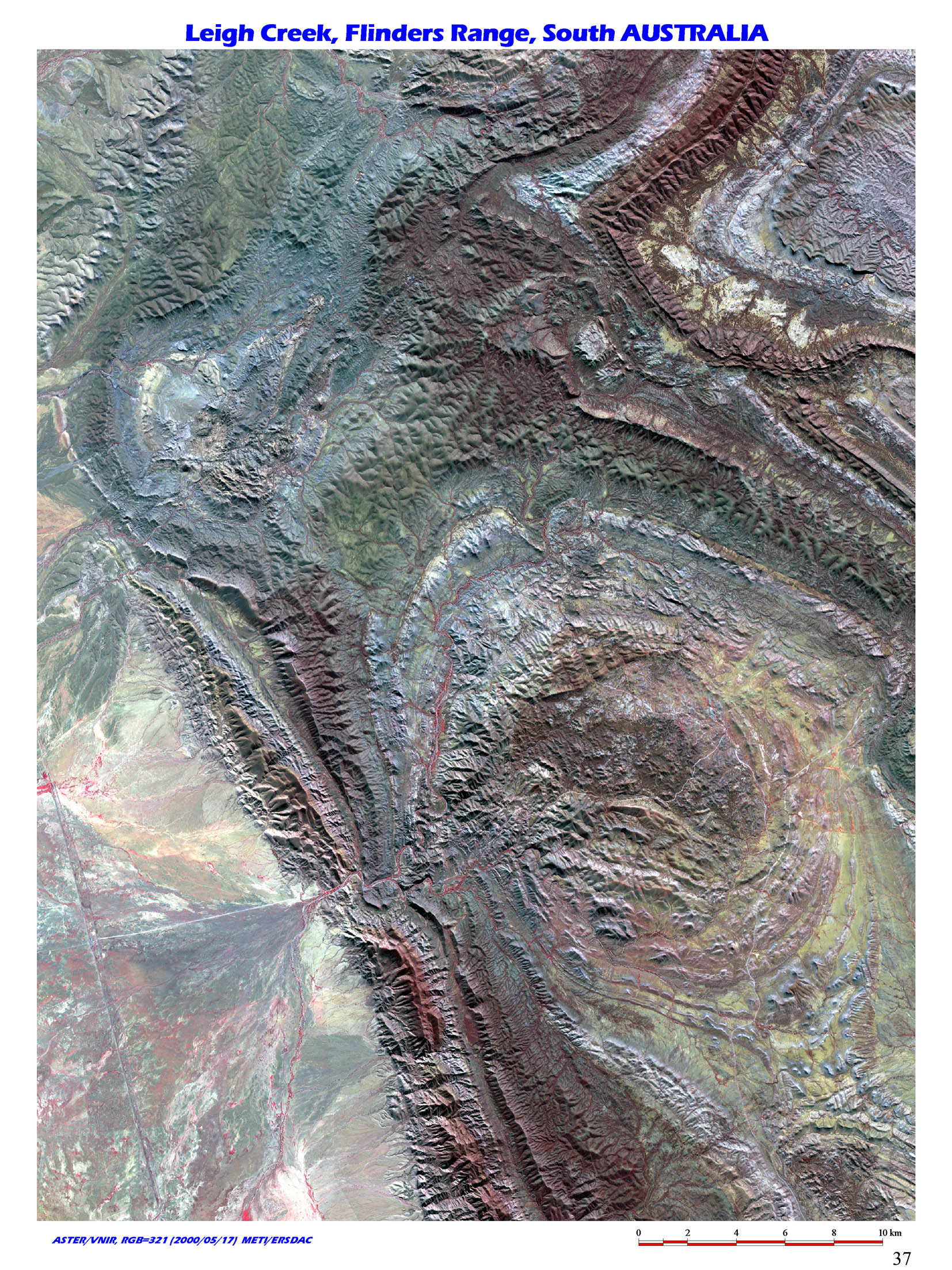 |
15. >Uplift of Proterozoic sedimentary rocks, Leigh Creek, Flinders Range, South Australia / (S31 00/E138 30) This is an area centering Leigh Creek, which is approximately 500km north of Adelaide, South Australia, and north of Flinders Range located west of Gawler craton. |
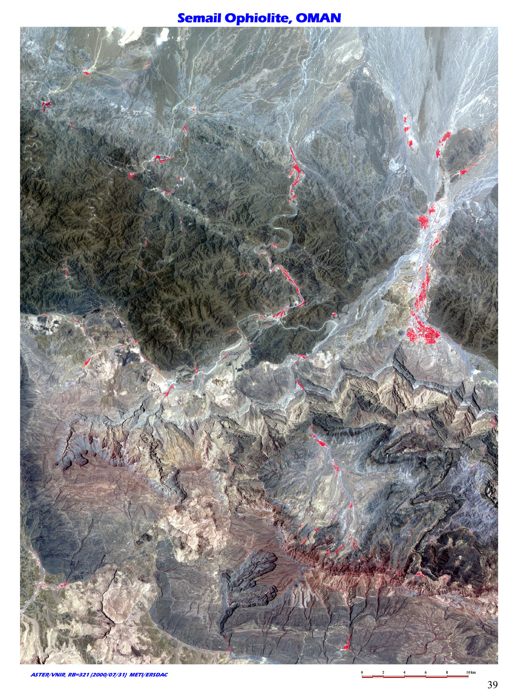 |
16. The world's largest outcrop of ophiolite, Semail Ophiolite, Oman / (N23 25/E57 15) Semail Ophiolite, nappe thrust in Oman, Arabian Peninsula is one of the largest ophiolites in the world. |
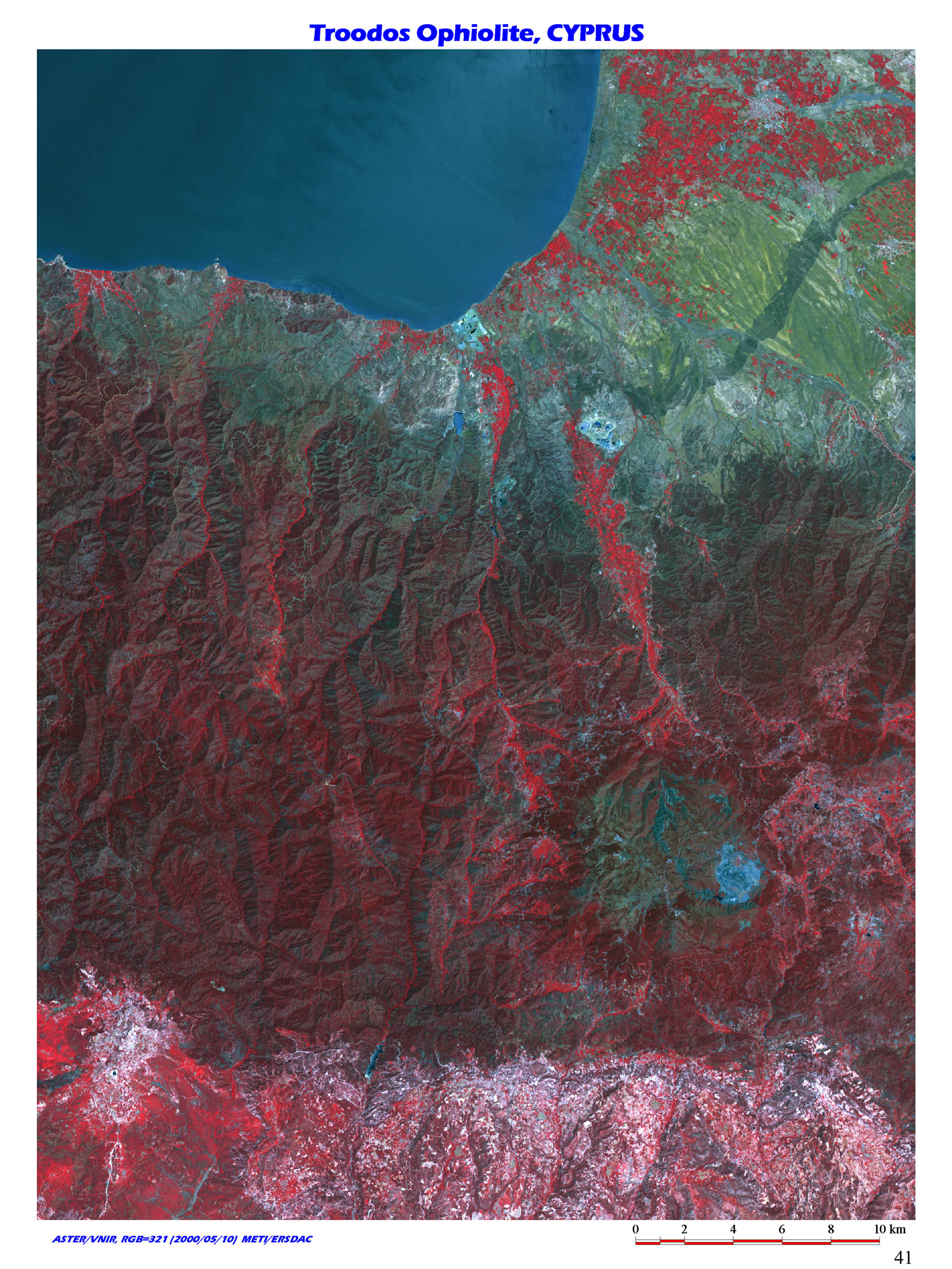 |
17. Troodos Ophiolite, Cyprus / (N35 10/E32 45) Southwest coast of Cyprus island, which floats in east of Mediterranean Sea. Dark colored rocks around the center of the image shows Troodos Ophiolite. Ophiolite is a bedded composite rock body, which consists of basalt, gabbro, peridotite and so on, which originate in orogenic zone. |
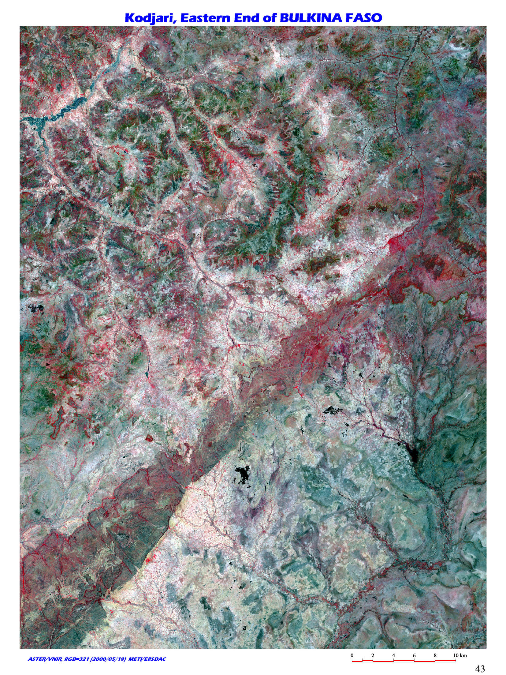 |
18. Precambrian Greenstone Belt, Burkina Faso / (N11 50/E01 55) This is eastern edge of Burkina Faso(near border between Niger and Benin) in Midwest Africa. Birrimian super group, correlated to Greenstone Belt is distributed in the region. In the super group, vein system gold ore deposit restricted by fault, exists in and around green stones, and exploitations are done manually here and there. |
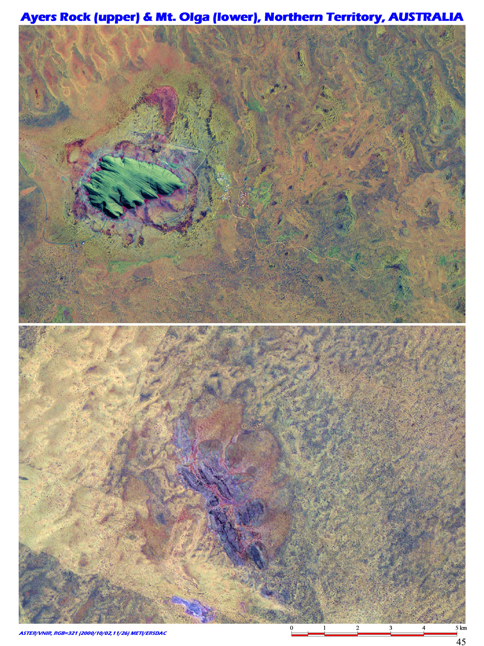 |
19. The world's biggest monolith, Ayers Rock (Uluru) and Mount Olga (Kata Tjuta), Northern Territory, Australia / (S25 20/W131 00) The image above shows Ayers Rock sitting in the center of Australia, and the image below shows Mount Olga located 30km west of it. |
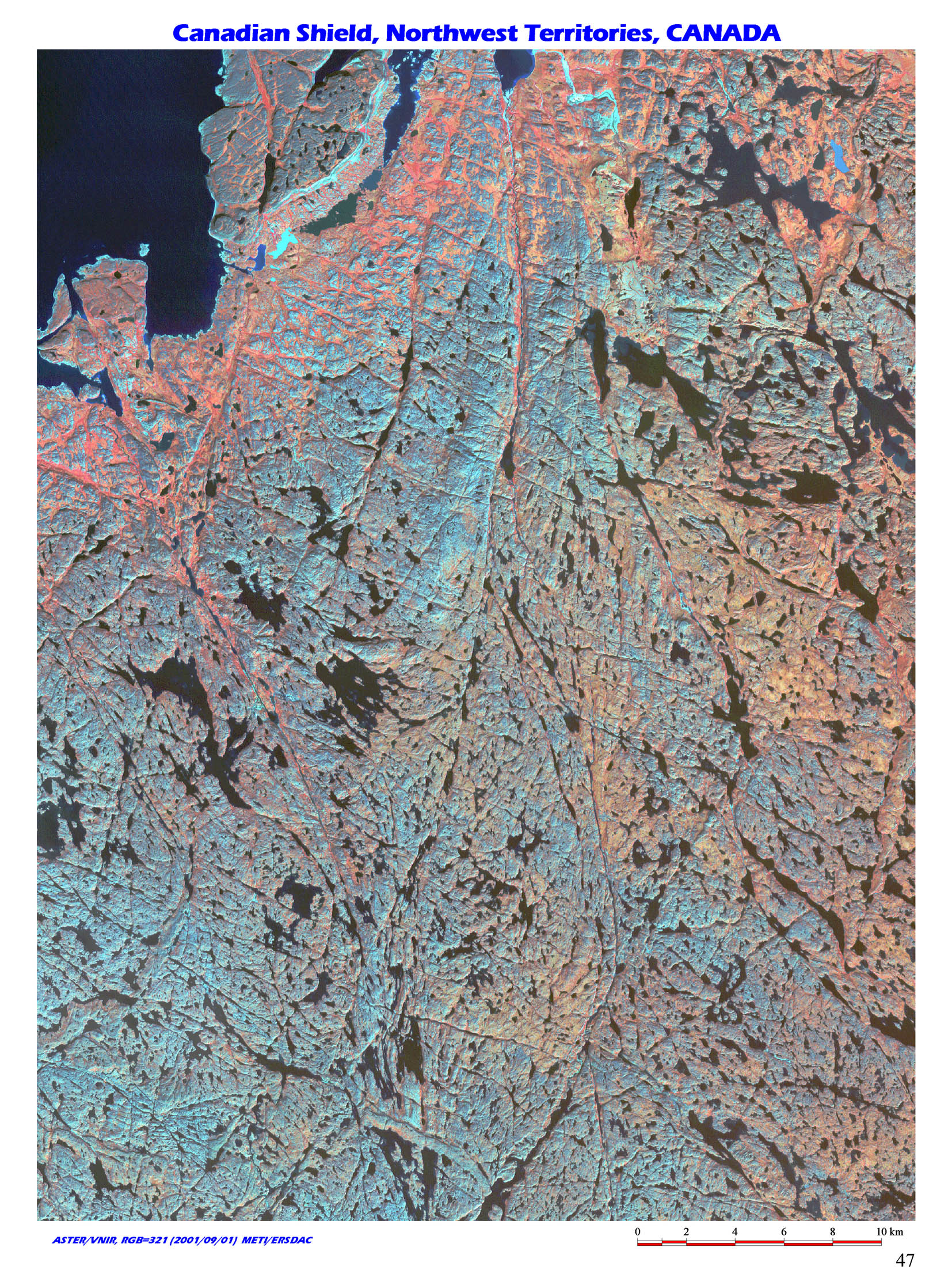 |
20. The world's oldest shield, Canadian Shield, Northwest Territories, Canada / (N67 30/W111 30) The image shows the world's largest shield, mostly located in Canada, in Precambrian distributed in northeast of North America. Canadian Shield is also called Laurentian Shield. |
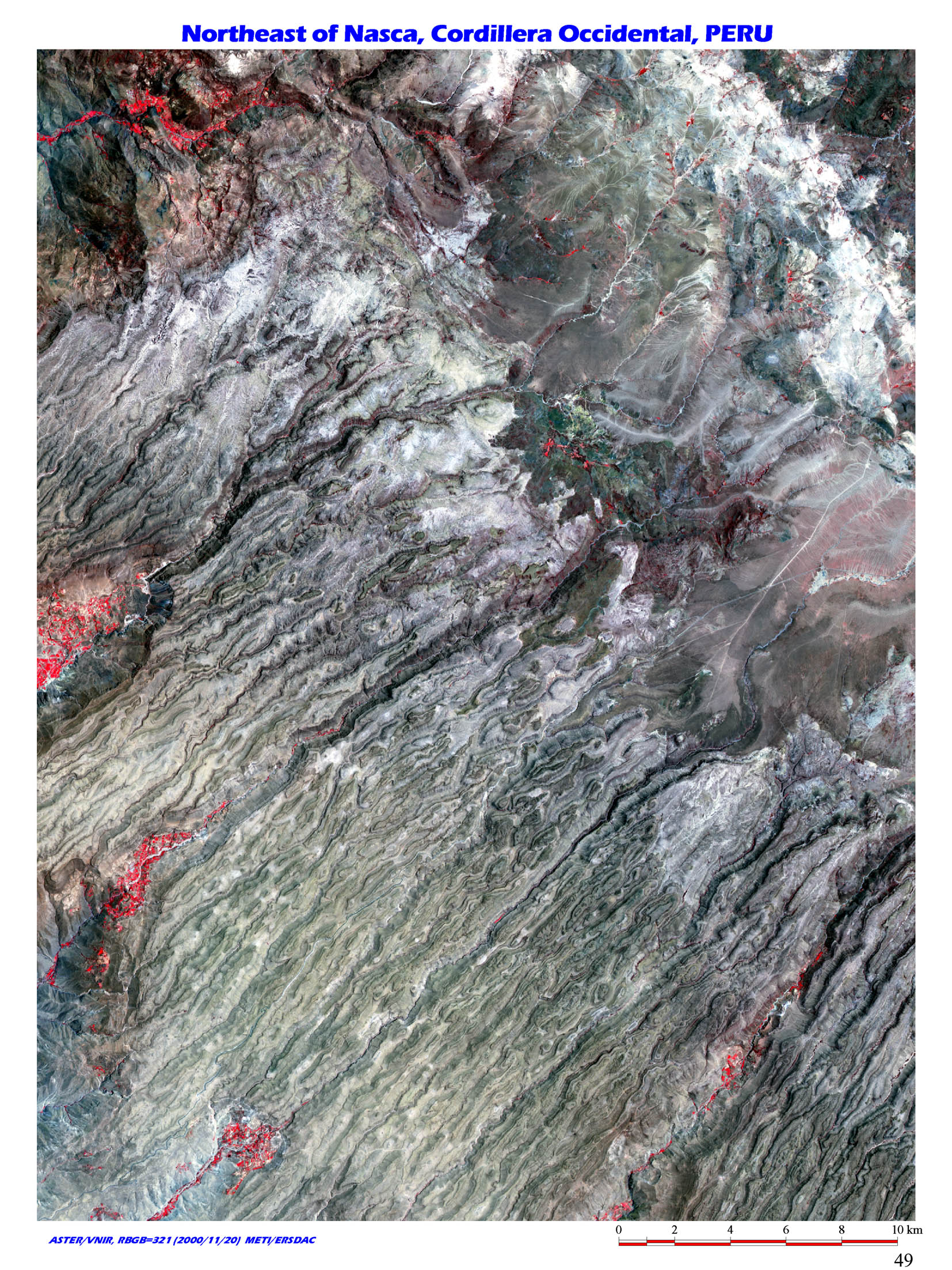 |
21. Earth engraving by erosion, Cordillera Occidental, Peru / (S14 40/W74 30) This image shows the western mountain ranges in northeast of Nazca city, south of Peru. This area is over 3,000m from sea level. Precipitation in the area is extremely low, one of the driest area in the world. Rainfall is rare but it often turns torrent, causing rapid current down the steep slope leading into Pacific Ocean, eroding low vegetation ground and forms straight lined deep valley. |
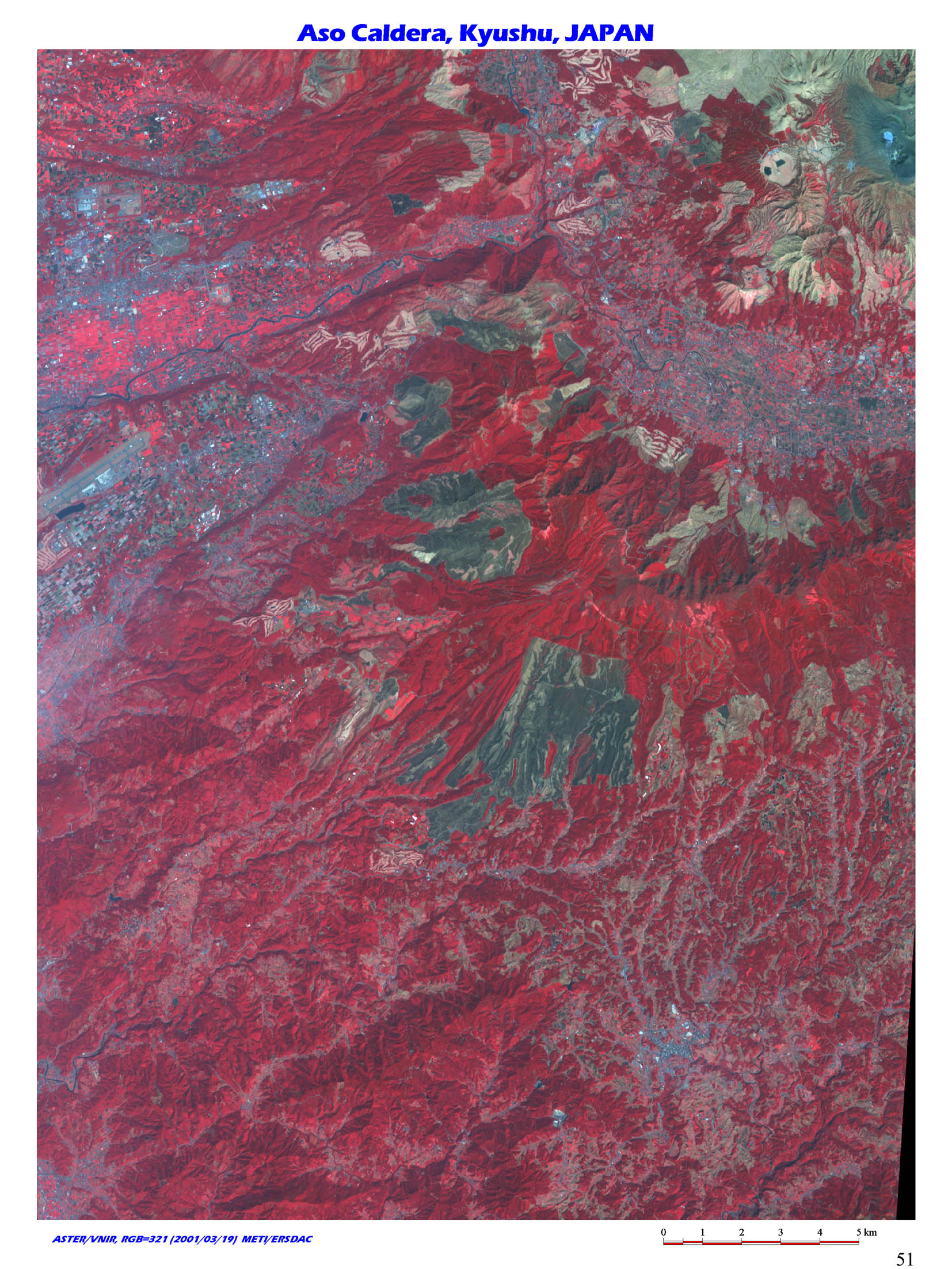 |
22. The world's largest class of caldera, Aso cardela, Kyushu, Japan / (N32 50/E131 00) This is the world's largest class of caldera located in the center of Kyusyu in Japan, which is 25km in north-south direction and 18km in east-west. The image is focused on southwest one fourth of the caldera. |
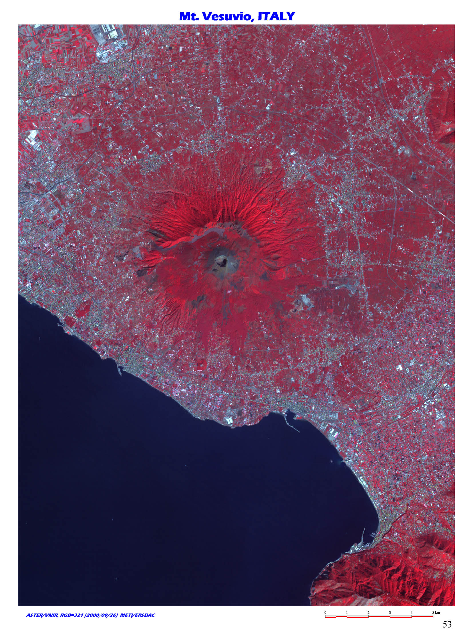 |
23. Catastrophic eruption that buried Pompeii, Vesuvio Volcano, Italy / (N40 45/E14 25) The image shows Vesuvio Volcano, a composite stratovolcano in Quaternary located east of Napoli, Italy. The basement consists of limestone from Jurassic to Cretaceous, sedimentary rocks in
Tertiary, and so on. Magma reservoir is considered to exist inside limestone in Triassic. |
 |
24. Debris avalanche by the eruption of St. Helens St. Helens Volcano, Washington, USA / (N46 20/W122 10) The image shows St. Helens Stratovolcano in Washington State, northwest USA. It belongs to High Cascades volcanic belt in North America. |
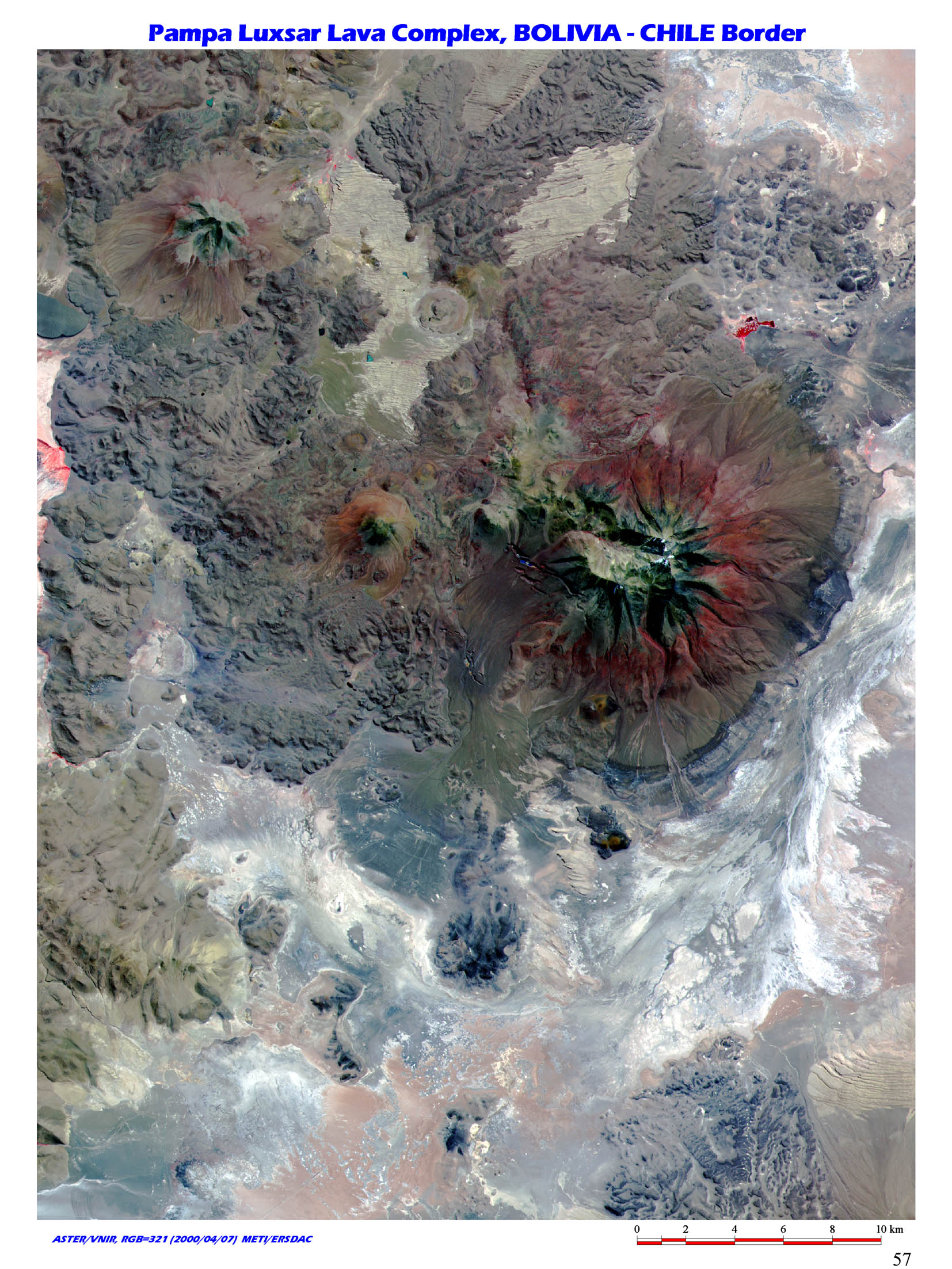 |
25. The active volocano in the Andes Mountains, Pampa Luxsar lava complex, Bolivia-Chile border / (S20 50/W68 10) This is Pampa Luxsar Composite Lava located around the border between Bolivia and Chile in South America. Cerro Luxsar of 3800m high sits in the center of the image. At upper right corner of the image, southwestern edge of Salar de Uyuni can be seen. |
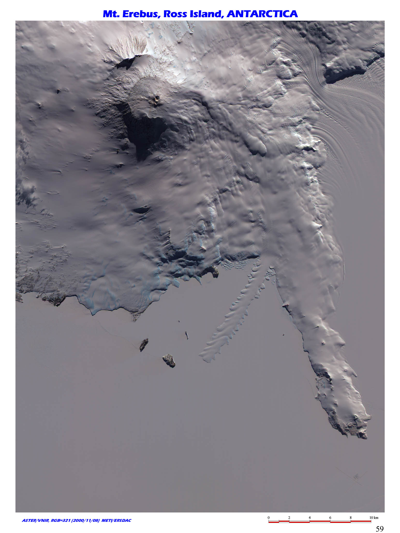 |
26. The hottest spot in Antarctica, Mt. Erebus, Ross Island, Antarctica / (S77 32/E167 10) Mr. Erebus is the most active volcano in Antarctic Continent. It was discovered in 1841 by James Ross expedition in England. Earnest Shackleton, an English explorer climbed to the caldera wall of the crater for the first time in 1908. |
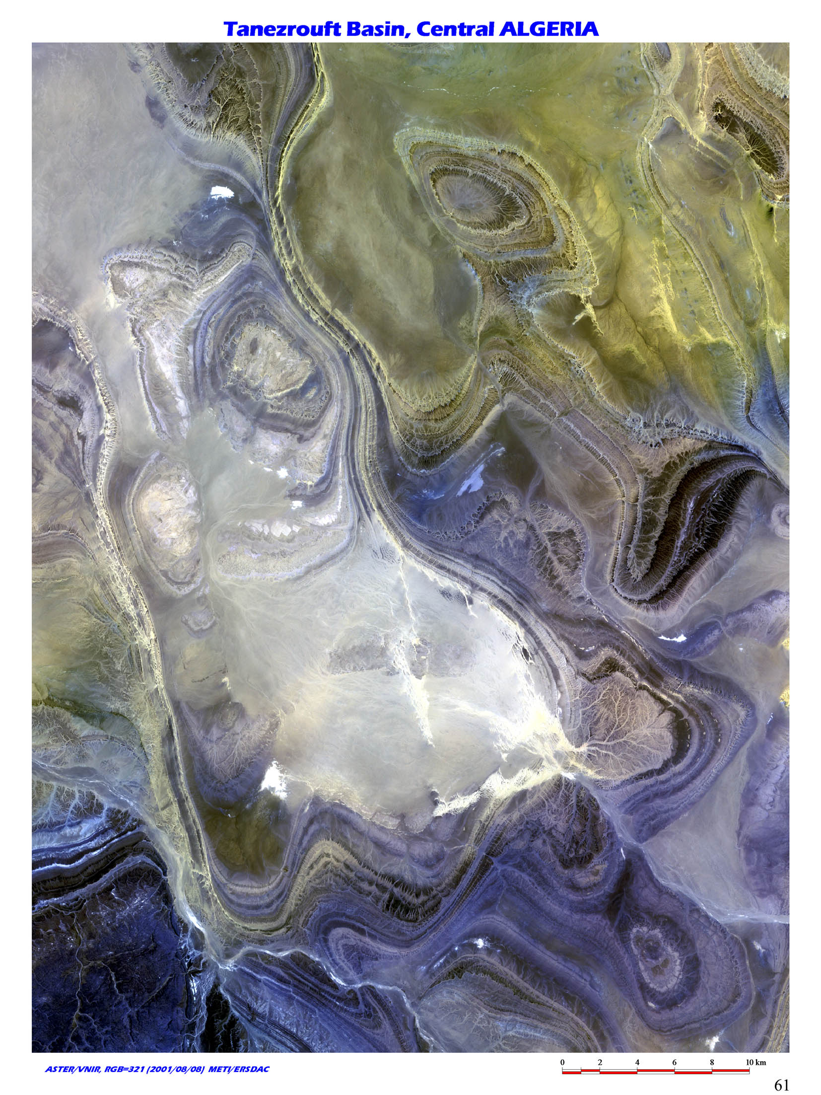 |
27. The abstract art by the Sahara, Tanezrouft Basin, Sahara Desert, Algeria / (N25 40/E02 45) The Image shows Tanezrouft Basin, in Sahara Desert in South Algeria, North Africa. As the word Tanezrouft means "land of terror", there is nothing but deserted land in the area. It is 150km away from here to the closest oasis, "In Salar". |
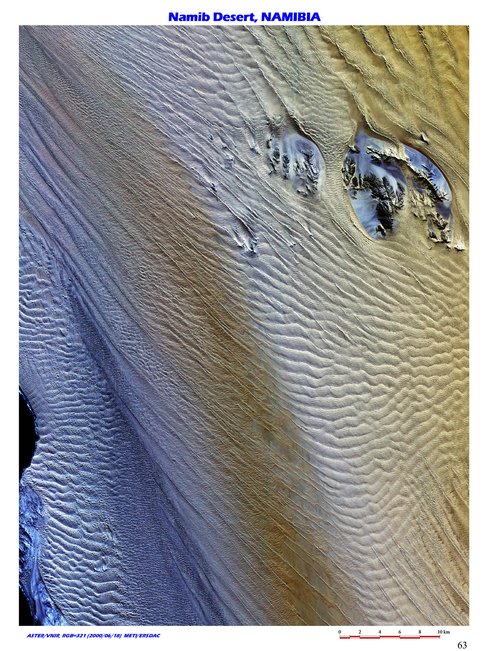 |
28. The interaction of ocean and desert, Namib Desert, Namibia / (S25 30/E15 10) This is where ocean and desert meets, an image of Namib Desert in southwest Africa. Namib Desert is namely, next to coastline. Mists made when warm air and cold Benguela Current meet is peculiar to the area, but rainfall doesn't reach inner desert area because the mists formed along narrow coastal zone scatter away instantly. |
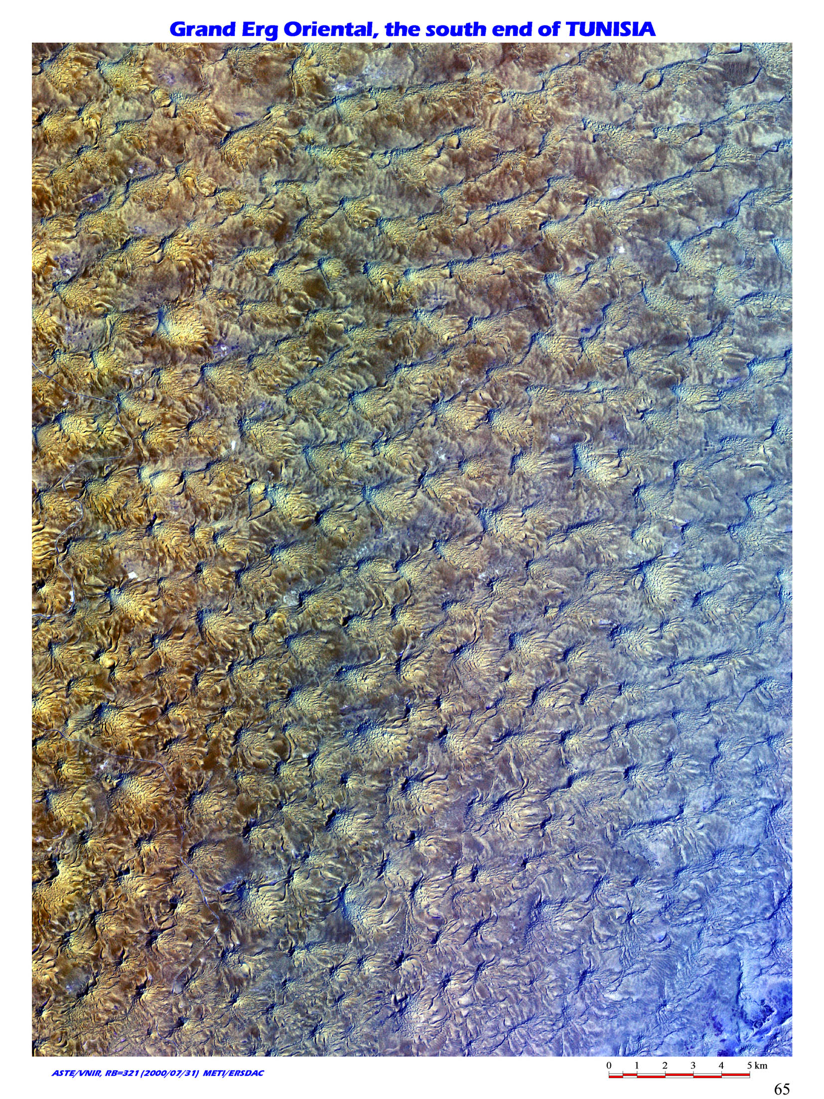 |
29. The star dunes in the Sahara desert, Grand Erg Oriental, Tunisia / (N30 20/E09 20) Sand dunes in Grand Erg Oriental, located near the border between Tunisia, Libya and Algeria in North Africa have peculiar form like star or jellyfish. |
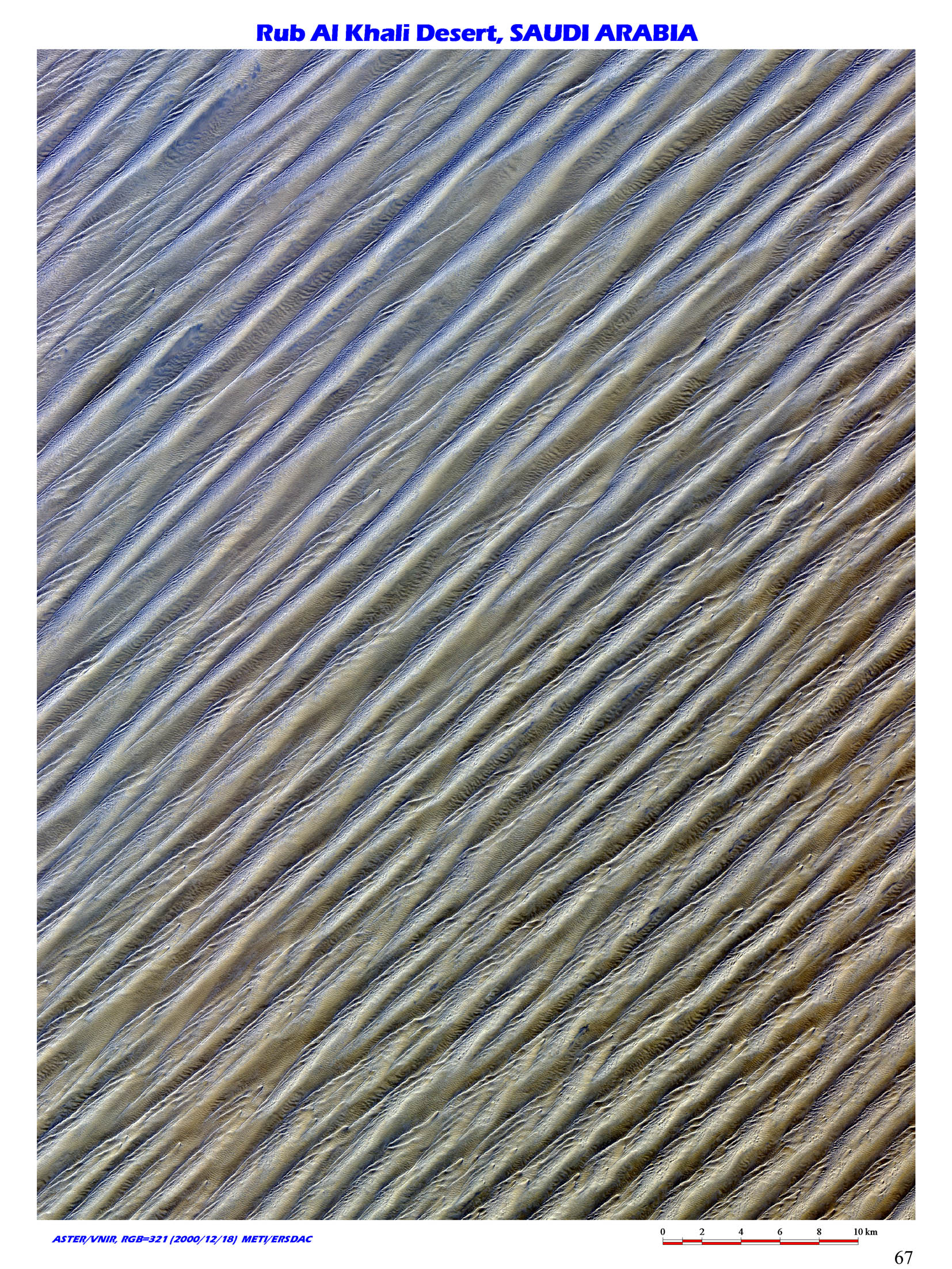 |
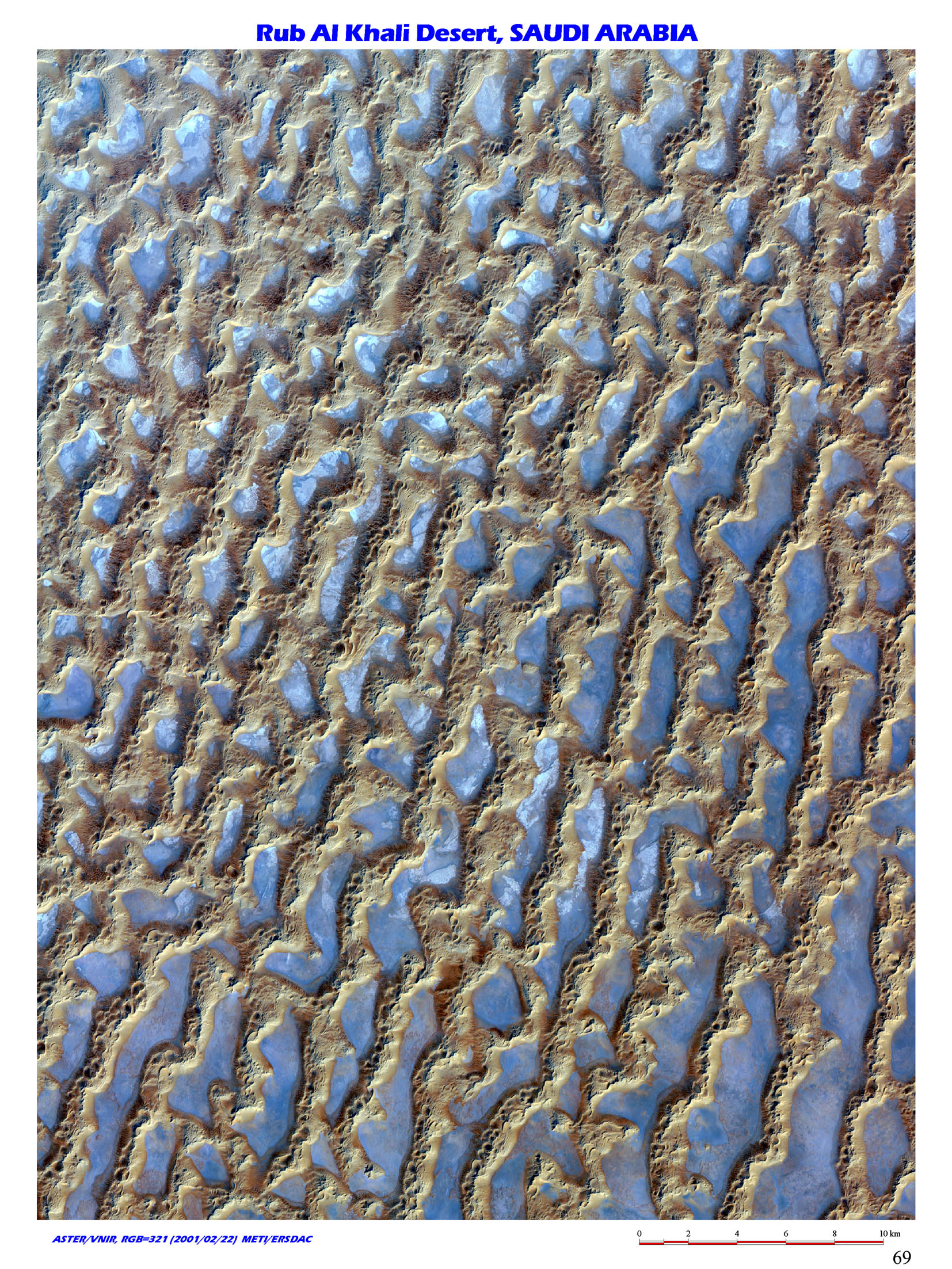
30. Endless dunes, Rub Al Khali Desert, Saudi Arabia / (N18 50/E48 20) This is a typical longitudinal dune in Rub Al Khali Desert in Saudi Arabia, southern Arabian Peninsula. Due to strong trade wind from northeast and immense supply of sand, sand dune in the area is formed parallel to wind direction. |
 |
31. Complex Crescentic Dunes, Rub Al Khali Desert, Saudi Arabia / (N20 30/E54 10) This is an image of Rub Al Khali Desert in Saudi Arabia, south of Arabia Peninsula. It is located north of the desert shown in the image no. 30. Lines of crescentic sand dunes, also called barchan sand dunes are distributed all over the image. Sand supply in such sand dune is small and wind blows from the same direction. |
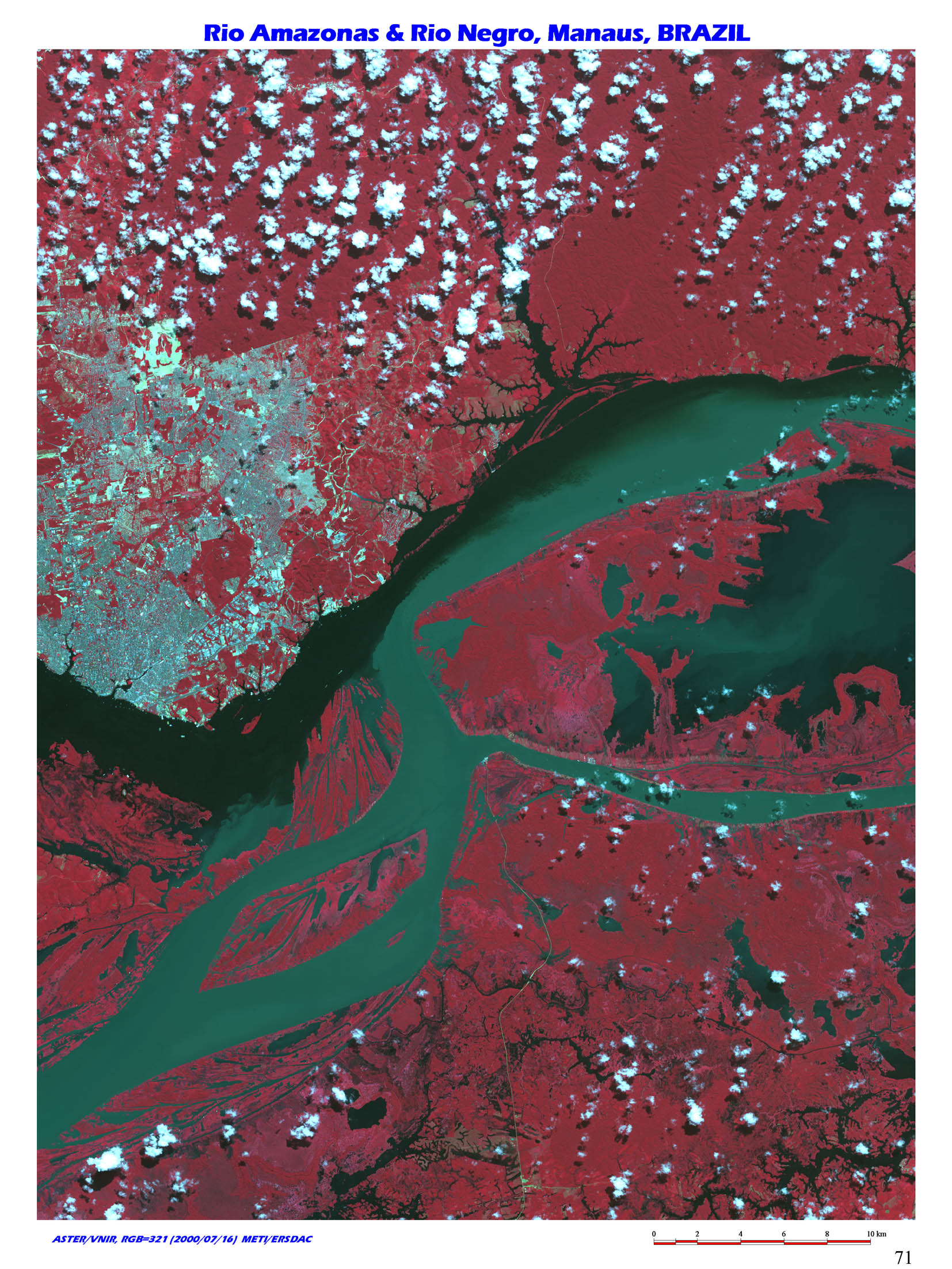 |
32. Density current ; Unmixed river water, Rio Amazonas and Rio Negro, Manaus, Brazil / (S03 10/W59 50) This is near Manaus, North Brazil, where Amazon and Negro rivers meet. Water flow from the two great rivers keep running unmixed for more than 100km, because Negro river contains small suspended matter, while Amazon contains much. |
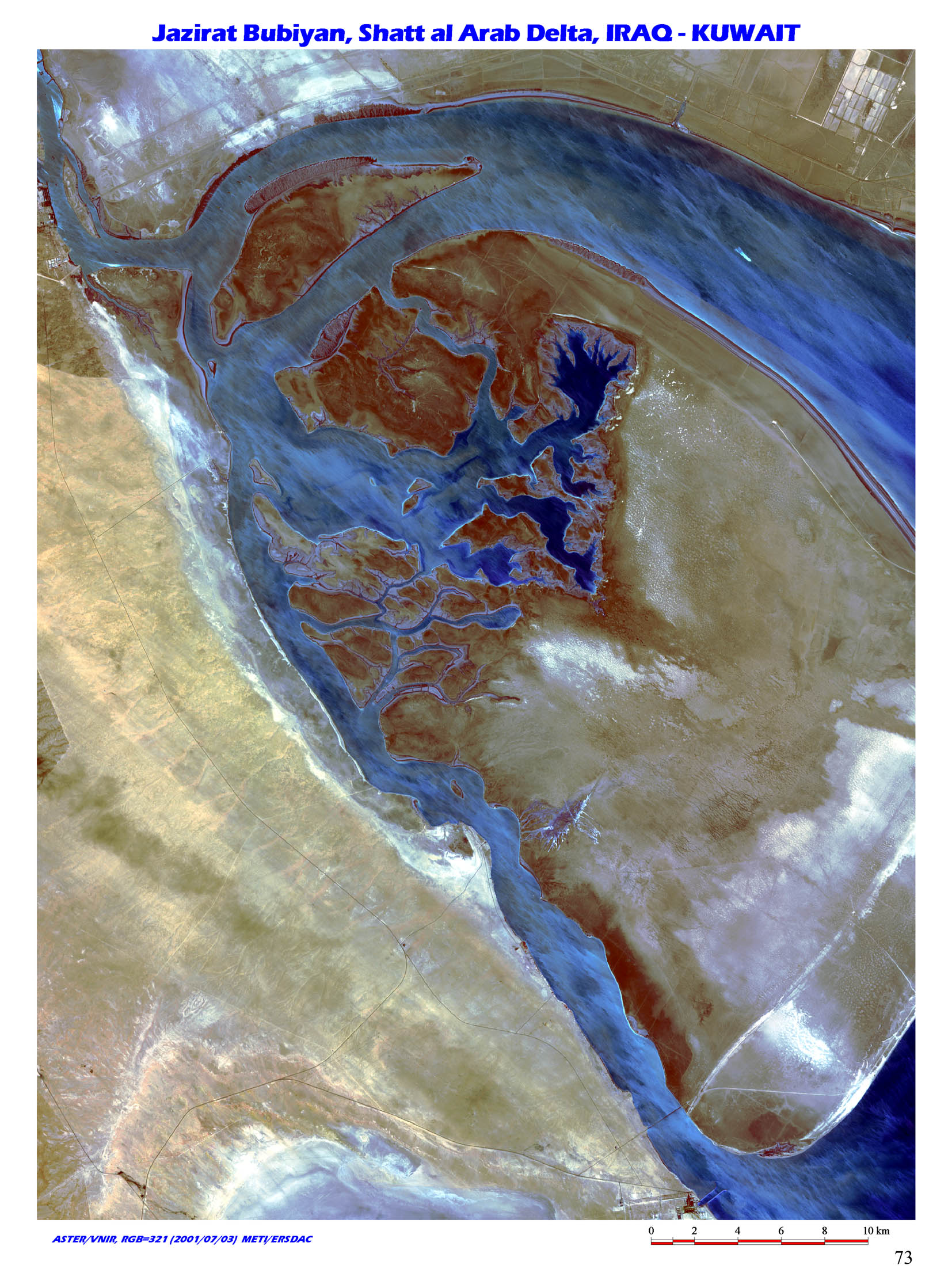 |
33. Mouths of the Tigris and the Euphrates, Shatt al Arab Delta, Iraq-Kuwait border / (N29 45/E48 00) This is Jazirat Bubiyan Island, located at the northern end of Persian Gulf, Middle East. Tigris and Euphrates rivers meet at Al Qurnah, where the river changes its name to Shatt al Arab river. The river flows into Persian Gulf after meeting Karun River flowing from Zagros Mountain. Large amount of sediments carried by the river forms vast delta at its mouth. Jazirat Bubiyan Island is at the southern tip of the delta, and border between Iraq and Kuwait runs across the island. |
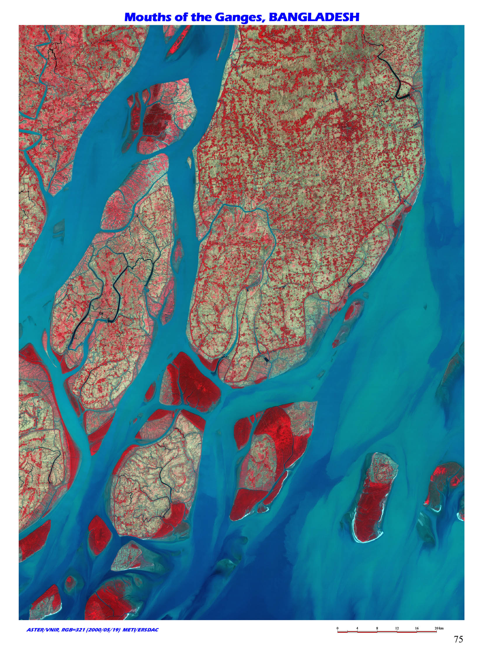 |
34. The world's largest class of delta, Ganges Delta, Bangladish / (N22 00/E90 45) This image is southernmost tip of Bangladesh, a part of Ganges Delta. Ganges and Brahmaputra rivers originate in southwest and northwest of Great Himalaya respectively. Where the two rivers meet, complicated braided streams are formed for as long as 300km as if the rivers flow into each other so hard and broke out in pieces. The image is just a small portion of vast Ganges Delta, of approx. 60,000km2. The world's highest mountains behind it and climate famous for its monsoon contributed to create the terrain. |
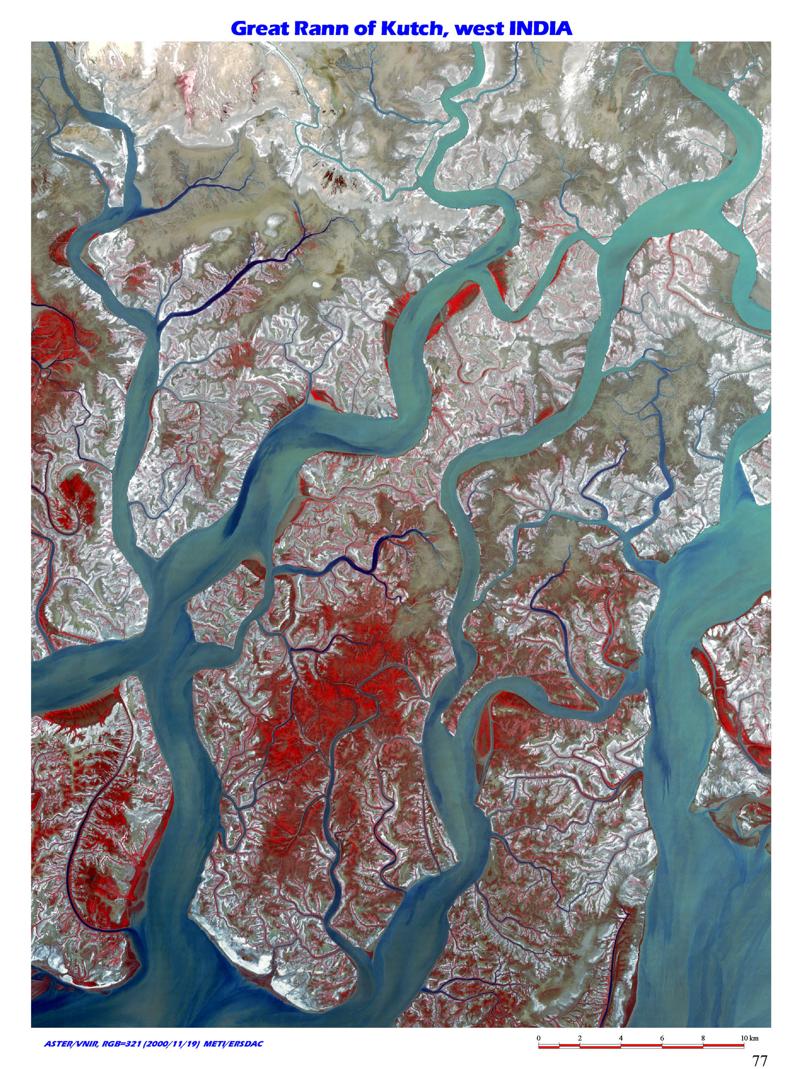 |
35. Great Maze inside Delta, Kutch Delta, India / (N23 50/E68 30) This image shows delta in Gulf of Kutch, western India. The area is surrounded with Great Rann of Kutch to the north, Little Rann of Kutch to the west and Kathiawar Peninsula to the south. |
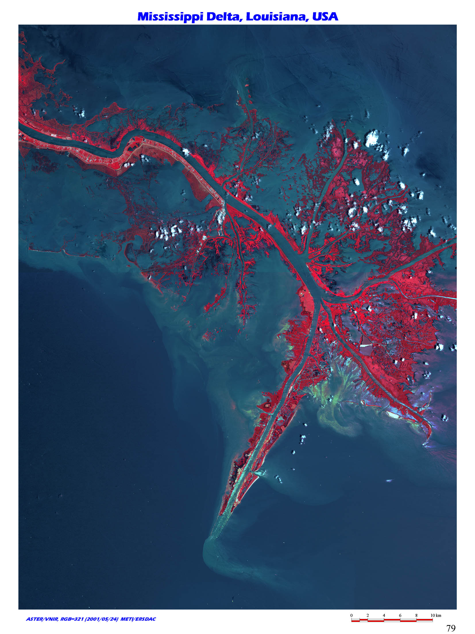 |
36. Bird Foot Delta, Mississippi Delta, Louisiana, USA / (N29 10/W89 30) This image shows a Bird Foot Delta, developed near the mouth of Mississippi River flowing into relatively deep part of Gulf of Mexico. Red parts in the image shows vegetation and light blue indicates the place dense with suspended solids and black ocean with little suspended solids. |
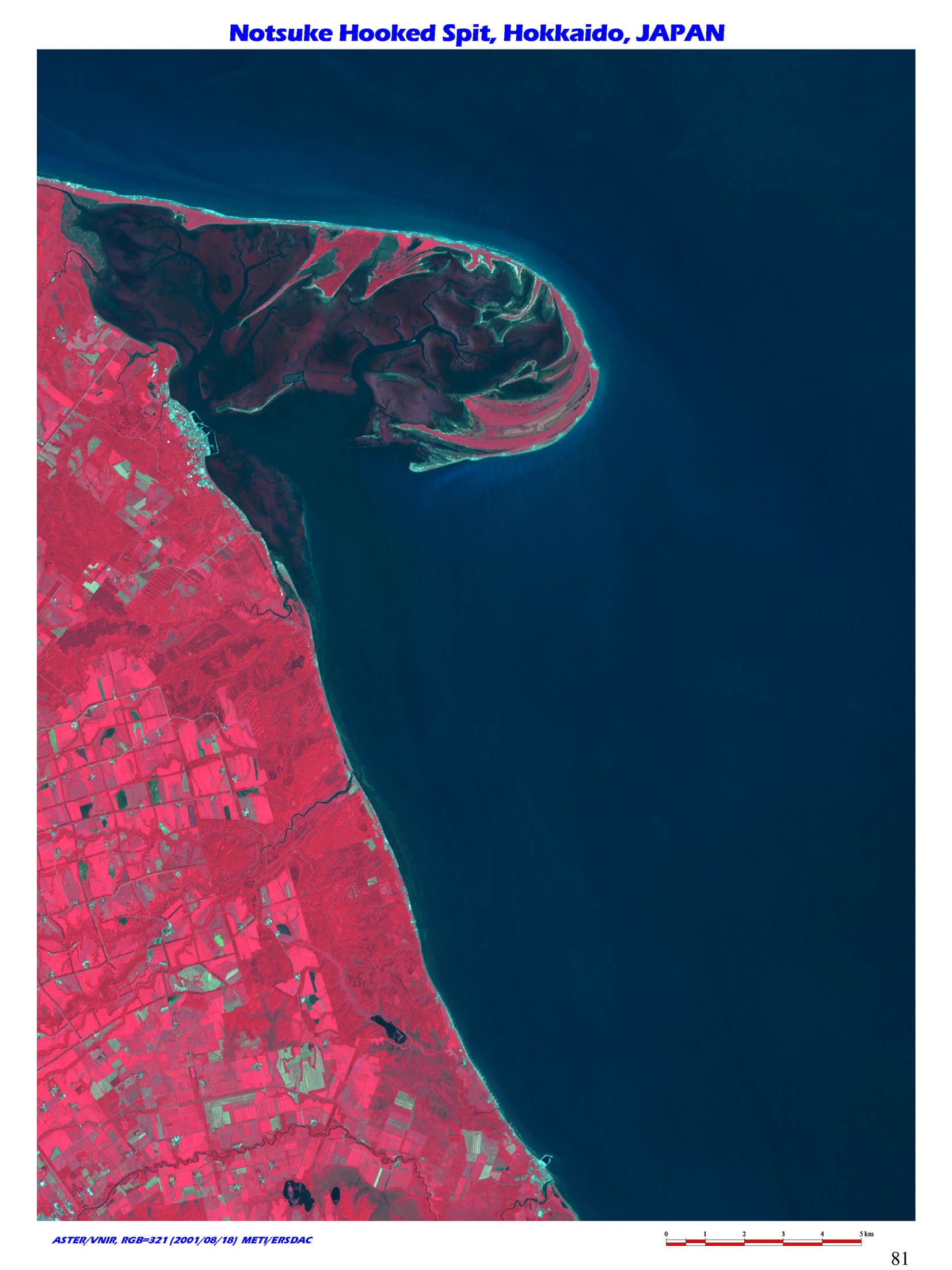 |
37. Hooked Spit, Notsuke Peninsula, Hokkaido, Japan / (N43 30/E145 15) The image shows unique spit of Notsuke Peninsula protruding in Strait of Nemuro, eastern Hokkaido. Gravel from coastal area or rivers is brought here by the coastal current. Edge of the peninsula is curved toward inland. |
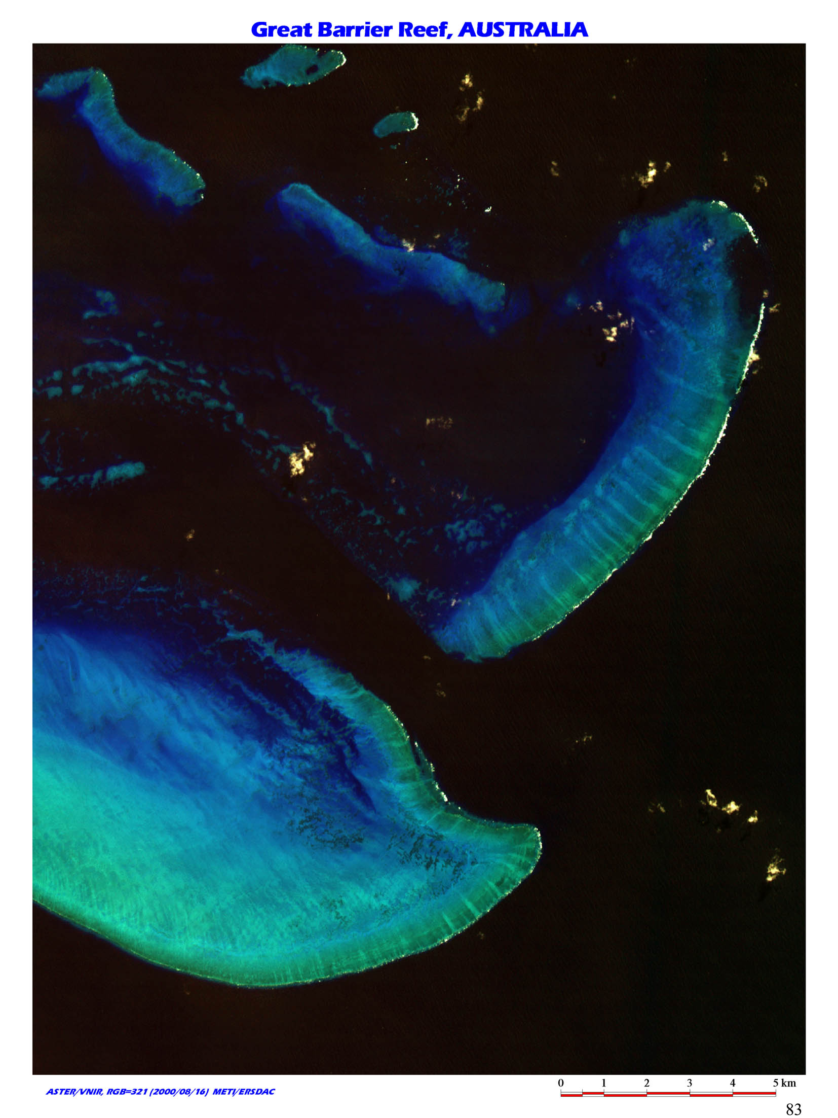 |
38. The world's largest size of coral reefs, Great Barrier Reef, Queensland, Australia / (S16 30/E145 50) Great Barrier Reef is the world's largest coral reefs, extending from south of Papua New Guinea down to the southern circle for more than 2000km. Coral reefs in the area developed along coastline of Australia, from a few kilometers to a few score kilometers away from it. |
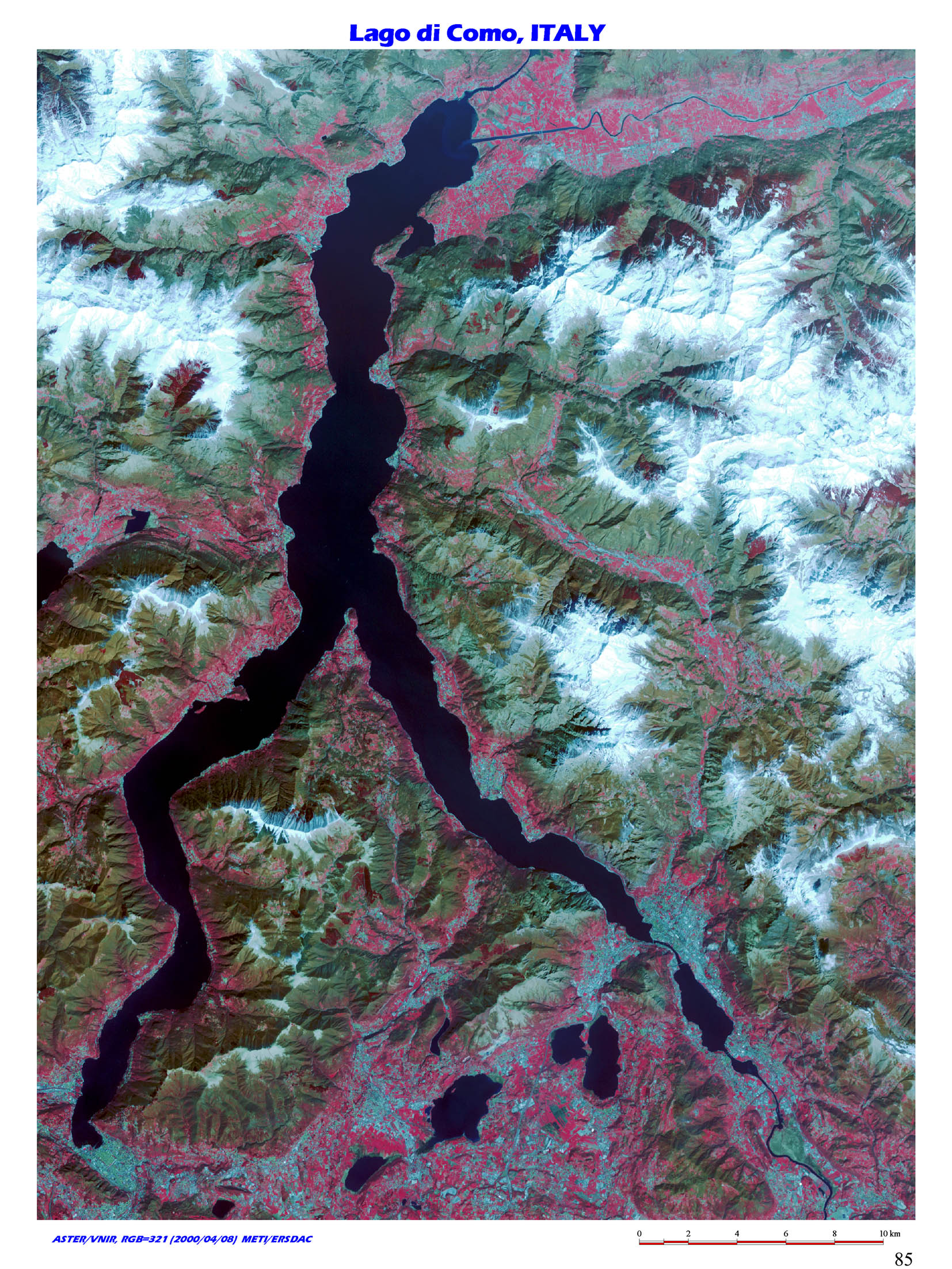 |
39. Glacial Lake, Lago di Como, Lombardia, Italy / (N46 00/E09 15) This is Lago di Como, approx. 40km north of Milano, Italy. The lake was dammed up by moraine along with Lago Maggiore and Lago di Lugano in the west. Area around here is a famous tourist spot called Lake District. Water from lakes in the area flow into Po River, which is connected to Adriatic Sea. Lago di Como is approx. 46km long, 4.3km wide and the maximum depth is 420m, the deepest lake in Europe. |
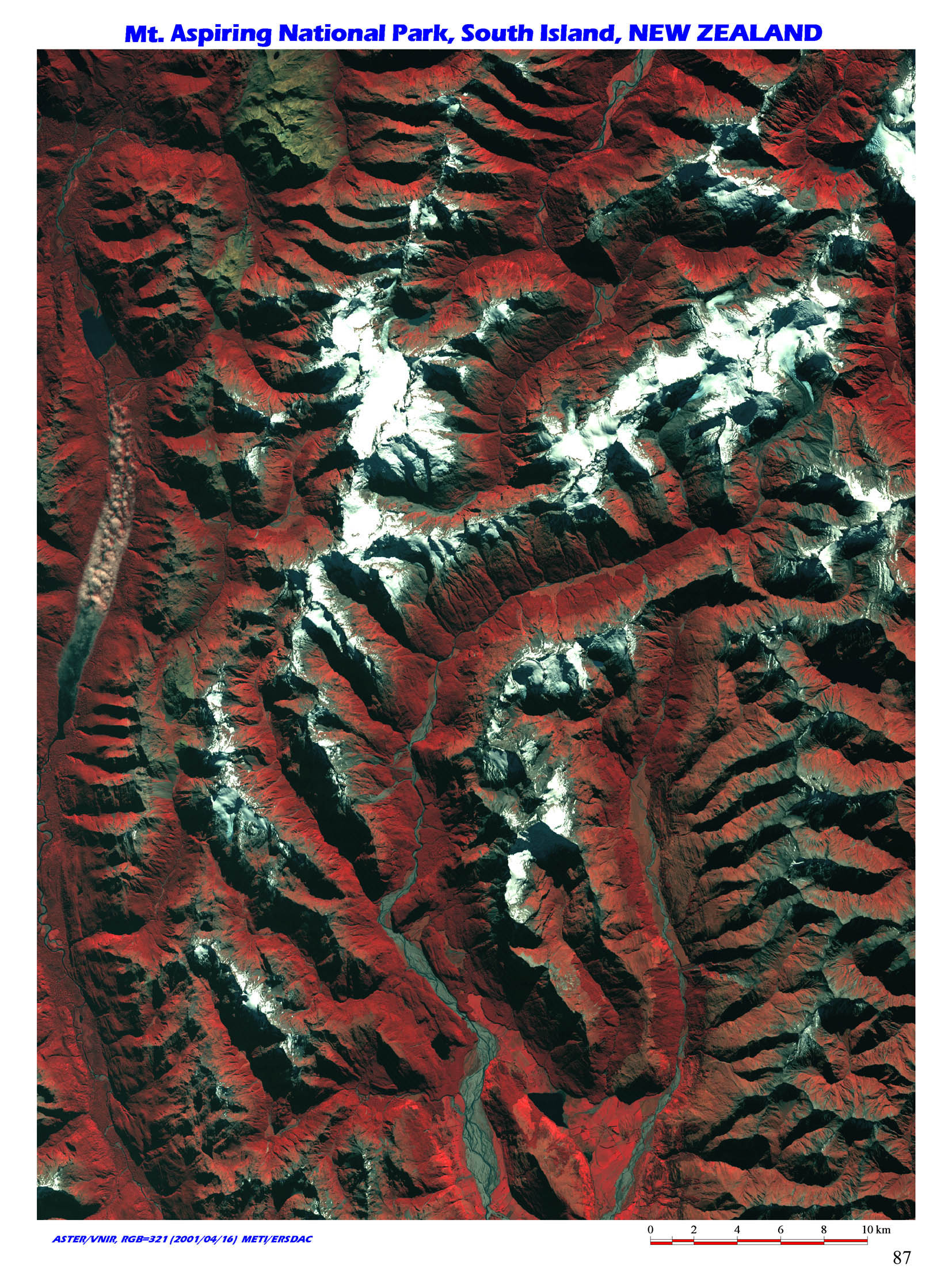 |
40. U-shape valley by glaiciation, The Aspiring National Park, S. Island, New Zealand / (S44 30/E168 20) This is Aspiring National Park, in South Alps Range, southwest of South Island, New Zealand. U-shape valleys were formed by glaiciation in the end of Glacial Age, 14 thousand years ago.
Generally, V-shape valley will be formed by fluvial erosion, while U-shape by glacial erosion. Cross section of U-shape shows contrast of steep wall and bottom flattened with fluvio-glacial deposits. |
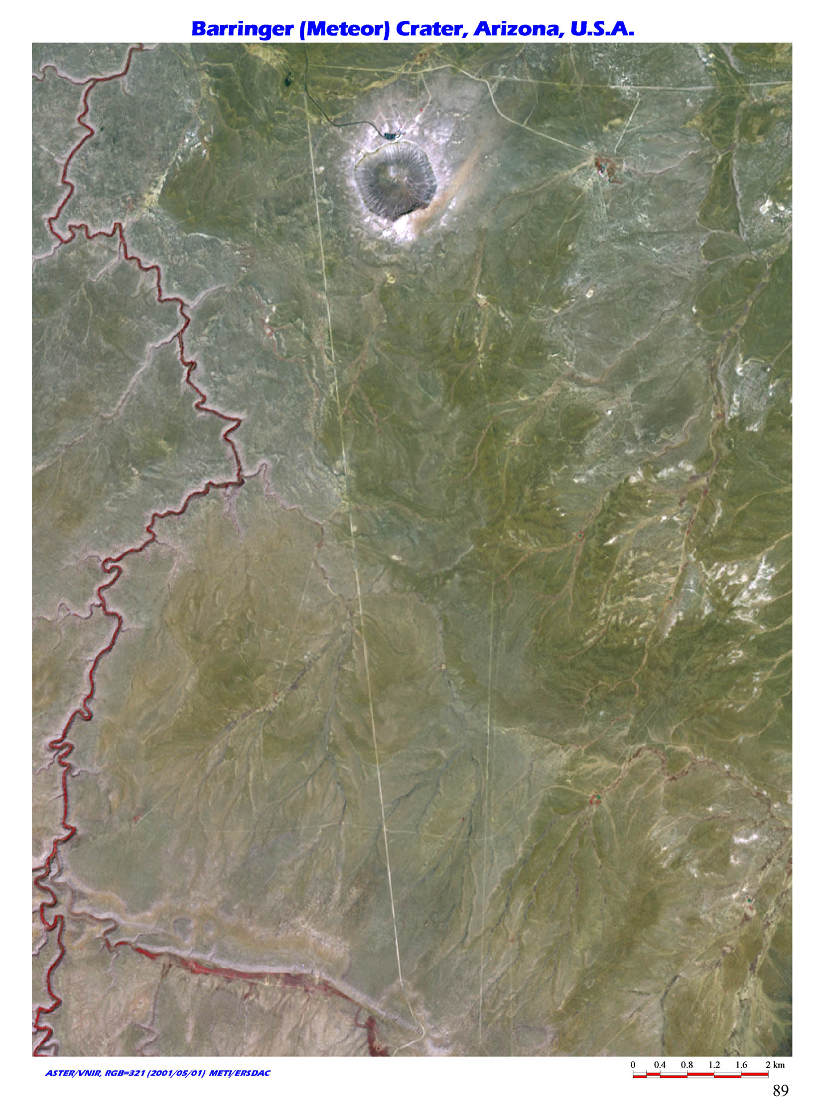 |
41. The world's first Confirmed Impact Crater, Barringer Impact Crater, Arizona, USA / (N35 00/W111 00) The impact crater, also called Meteor crater of approx. 1.3km of diameter and 145m depth is located in Colorado Plateau near Flagstaff, north of Arizona, USA. By the discovery of coesite and stishovite, minerals made when meteorite hits on earth ground, the crater was officially recognized as an impact crater for the first time in the world's history. |
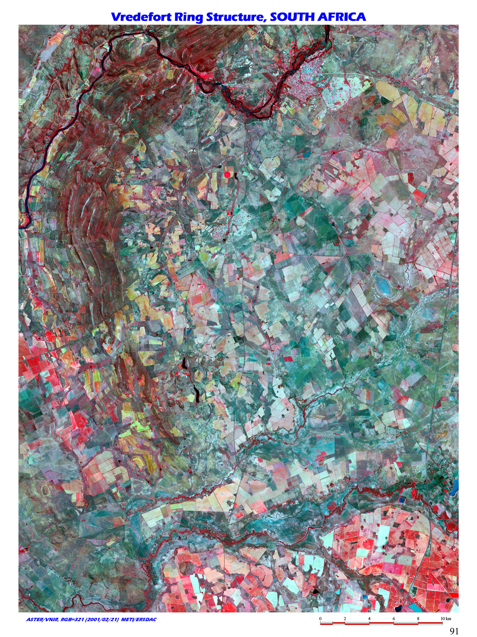 |
42. The world's largest size of impact crater, Vredefort Ring Structure, South Africa / (S27 10/E27 30) Vredefort Ring Structure located 120km to southwest from Johannesburg, mid-north of South Africa. Although this ring structure is not officially confirmed to be an impact crater, it is believed to be one made approx. 2 billion years ago from the fact that minerals made by meteorite collision was found and based on other geological features. Its diameter is beyond 100km, which is the largest of all impact craters in the world. The image is focused on southwest part. |
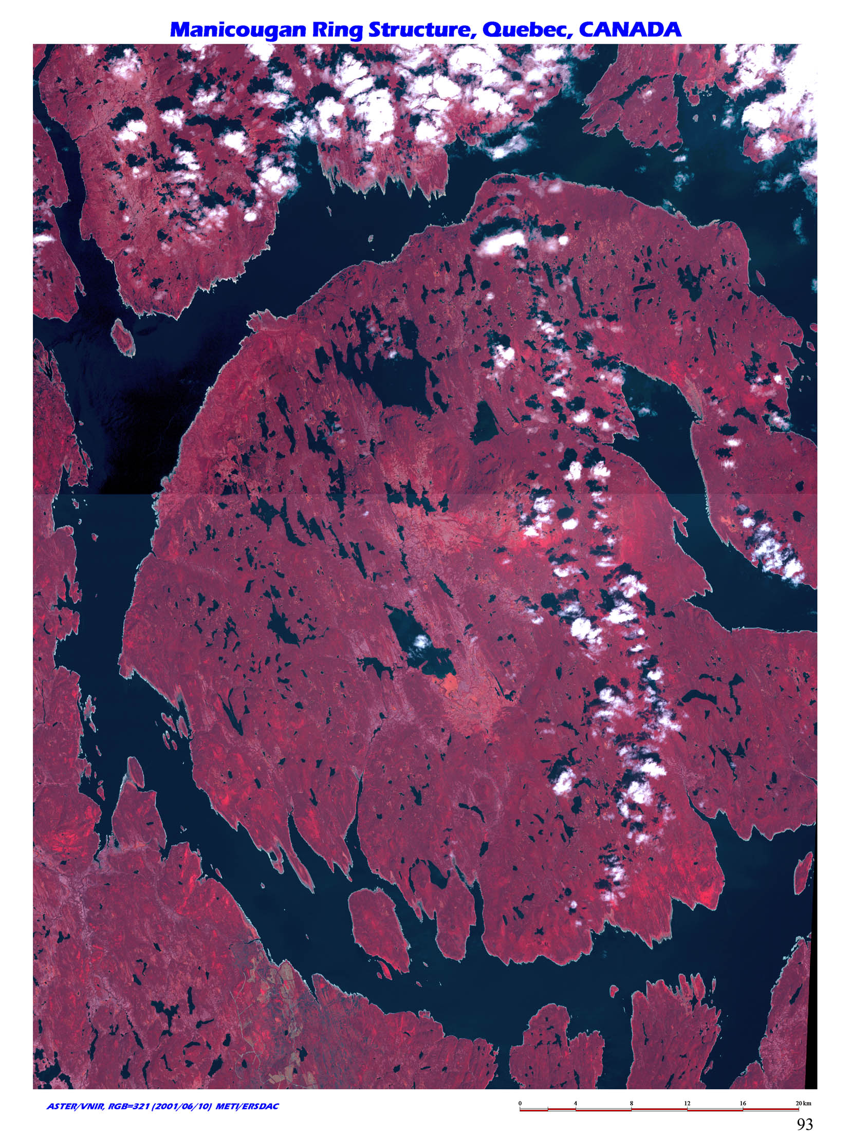 |
43. The world's largest class of impact crater, Manicougan Imapct Crater, Quebec, Canada / (N51 25/W68 40) Manicougan Impact Crater in southern Labrador in Quebec, Canada, is considered one of the world's largest impact craters though it is not officially recognized. It is believed to have been made by the collision of meteorite more than 200 million years ago, and the land was further lowered by the movement of glacier to south, retrograde and erosion. |
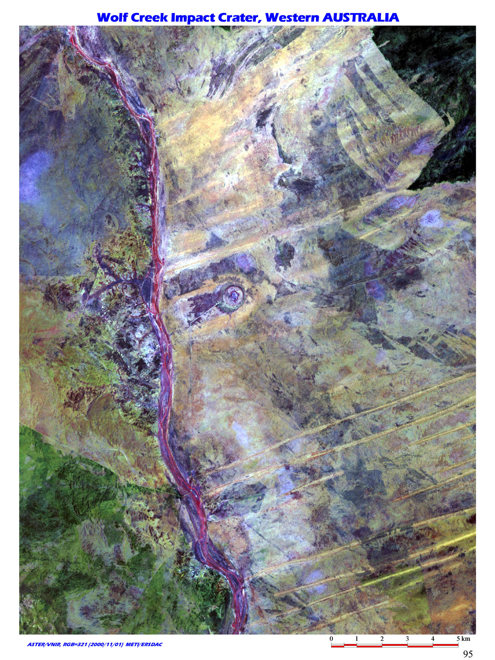 |
44. The world's second largest impact crater, The Wolf Creek Impact Crater, West Australia /(S19 10/E127 50) This is the Wolf Creek Impact Crater located near the border between Western Australia and Northern Territory, mid-northern Australia. The shape is relatively well preserved. Diameter of the crater is approx. 840m and was formed 300,000 years ago. This is the largest one next to Barringer in USA among all the officially recognized impact
craters. |
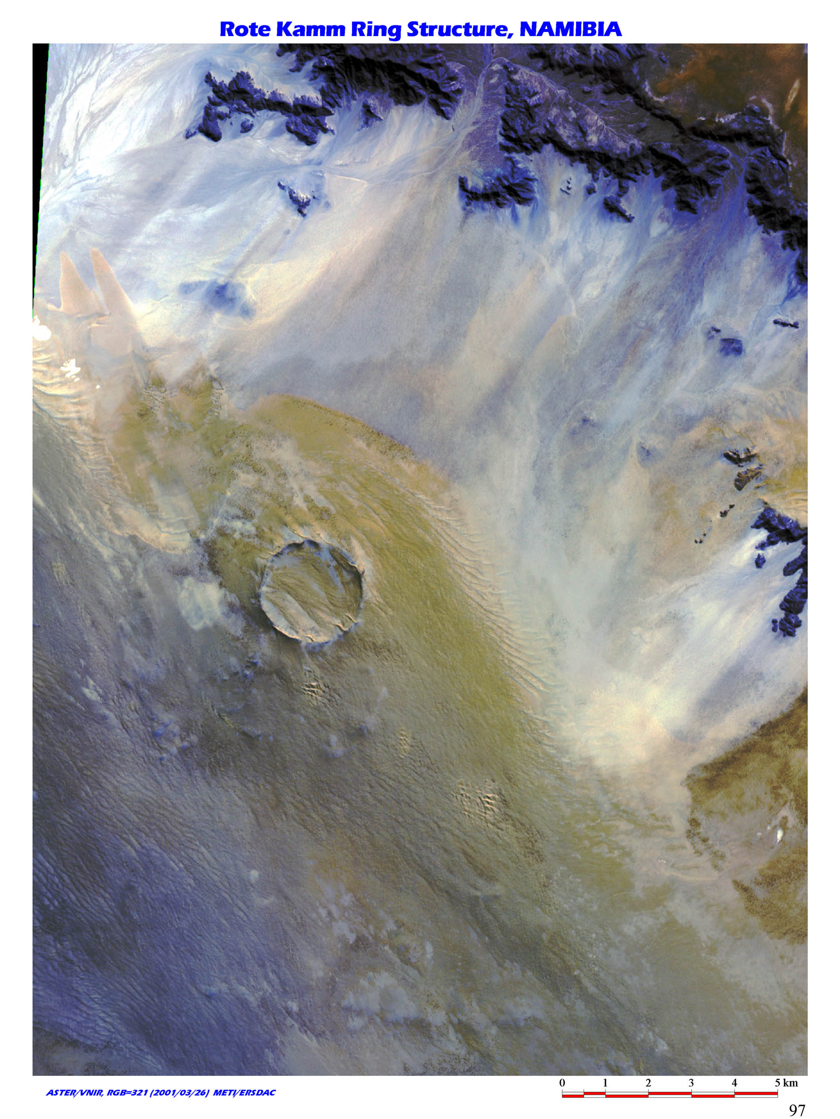 |
45. Impact crater coverd with desert sand, The Roter Kamm Impact Crater, Namibia / (S27 45/E16 20) Roter Kamm Impact Crater, located southern edge of Namib Desert, southwest Africa, is prominent with its perfect circular form, although dent inside is filled with aeolian deposit. The crater is 2.5km in diameter and was made 3.7 million years ago (not officially recognized). |
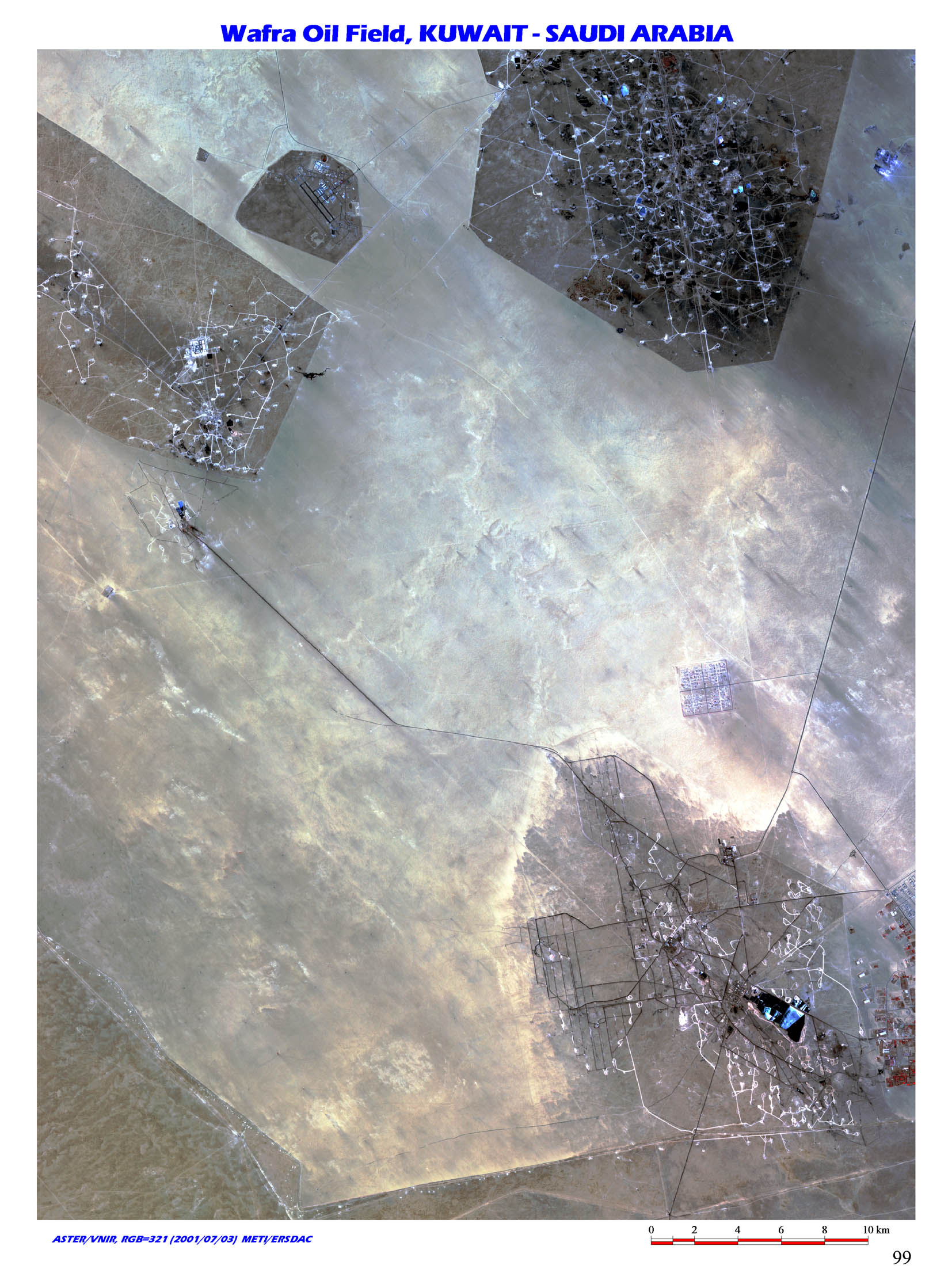 |
46. Oil resource in the neutral zone, Wafra Oil Field, Kuwait-Saudi Arabia / (N28 45/E47 45) In the neutral zone beyond Saudi Arabia and Kuwait, approx. 590,000 barrels of oil per day are produced from 5 fields (as of 1999). Oil reserves in the area is estimated to be approx.
5 billion barrels. Dry climate in the area makes it possible to clearly observe production facilities and stretches of road in Wafra Oil Field.
The oil field was discovered by Getty Oil Co. in 1953, the earliest among all the oil fields under operation in the neutral zone. Texaco Inc. and KOC took over the oil production later. |
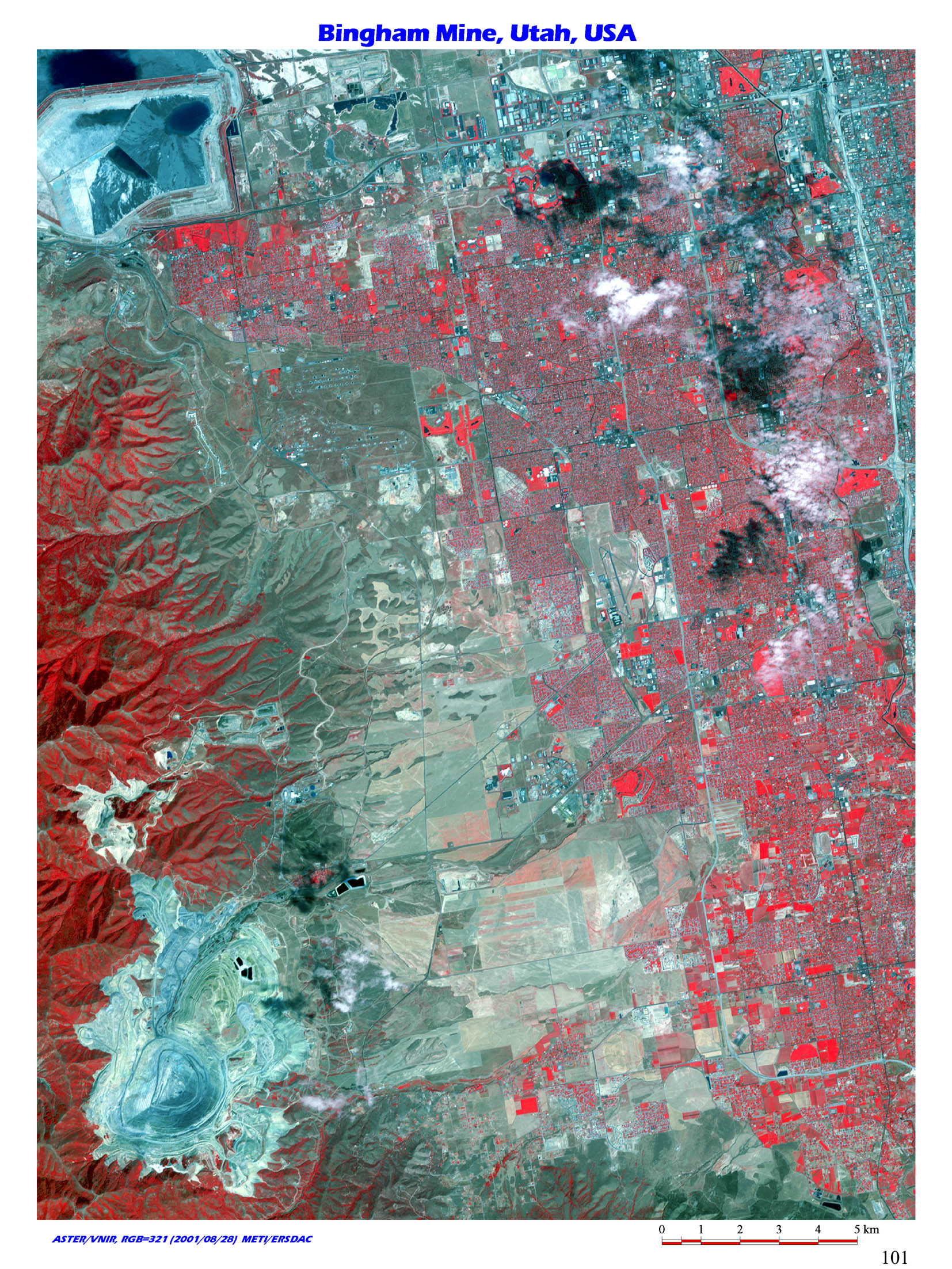 |
47. The world's first developed open pit porphyry copper mine, Bingham Mine, Utah, USA / (N40 30/W112 15) This is the typical open pit porphyry copper mine in Bingham Mine, located 20km southwest of Saltlake city, Utah, USA. The monzonite porphyry intruded Pensylvanian system. The mineralization disseminated copper and contact metasomatism (skarn) between limestone and porphyry of copper, lead, zinc and silver. The ore body forms zonal distribution, from intruded porphyry toward outside; copper_copper/lead/zinc_lead/zinc/silver_silver/gold exists. |
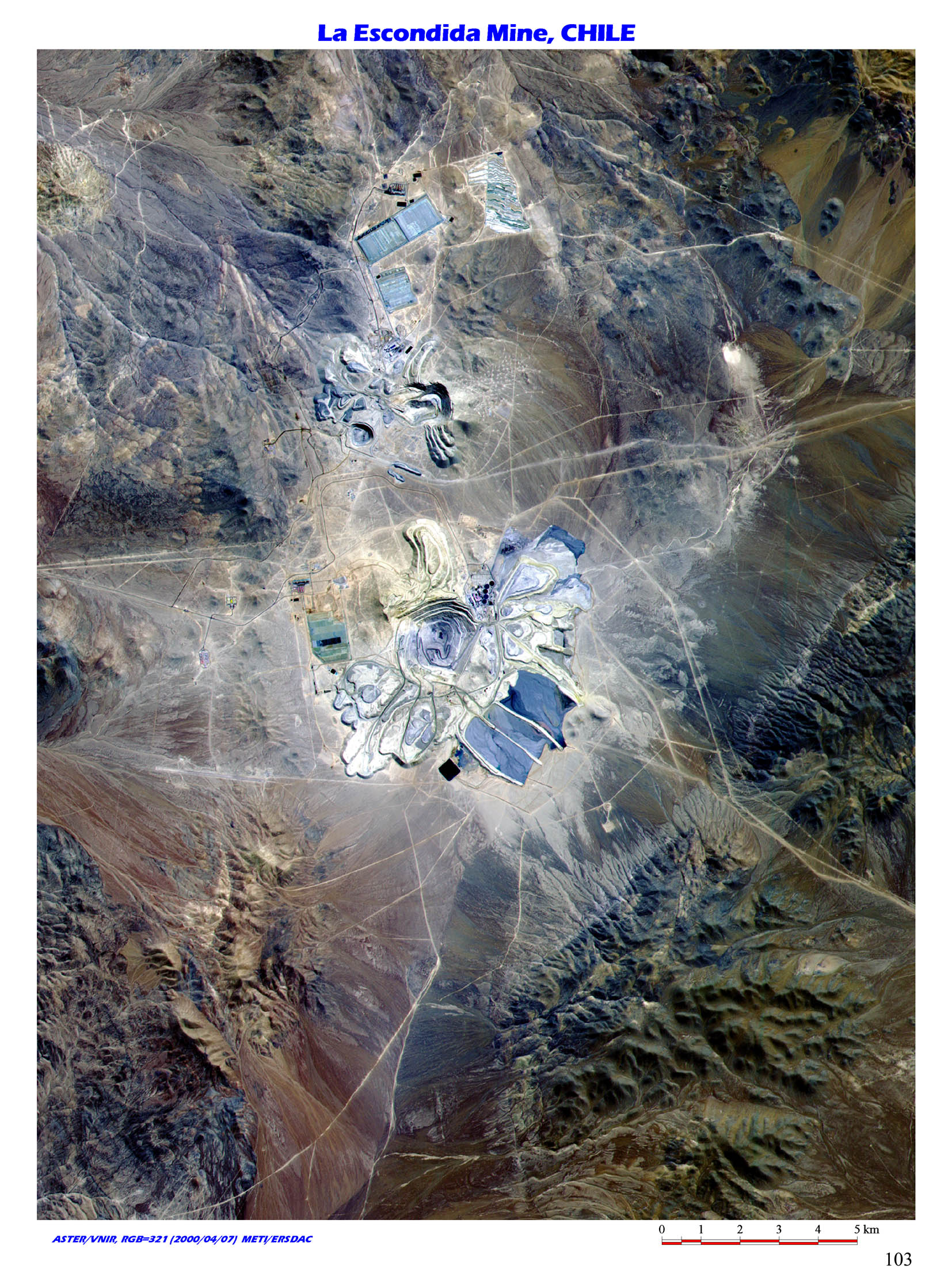 |
48. The world's largest porphyry copper mine, La Escondida, Chile / (S24 10/W69 00) This is La Escondida located in Puna de Atacama of over 3,000m above sea level, in northern Chile, South America.
The world's largest porphyry copper mine started its operation in 1990 by a company in Australia under the cooperation of Japanese companies.
Part of ore mined here is transferred to Japan for refining. |
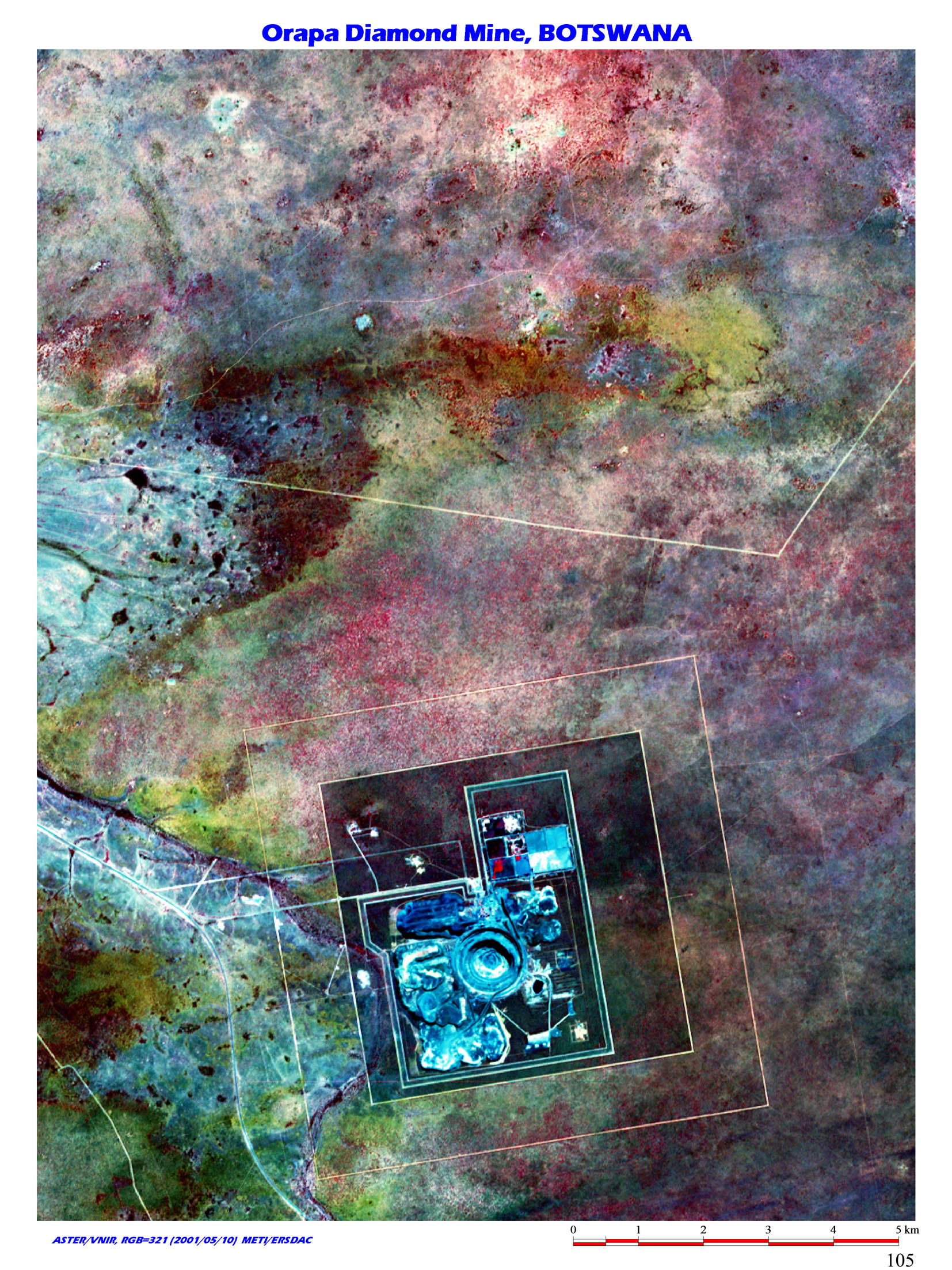 |
49. The largest diamond mine in Botswana, Orapa Diamond Mine, Botswana / (S21 30/E25 40) Orapa Diamond Mine is the largest diamond mine in Botswana, located in the center of Botswana, southern Africa.
It is also famous for being one of the world's largest kimberlite type mine. The diamond mine is operated by Debswana corporation whose stock is owned by De Beers Co. and government of Botswana, 85 % and 15 % respectively.
Ever since it was discovered in 1967, the diamond mine contributed to the economy of the destitute country to have the greatest influence in diamond market. In 1971, income brought by the diamond mine constituted more than half the GDP of Botswana. Orapa mine is printed on postage stamp in the country. |
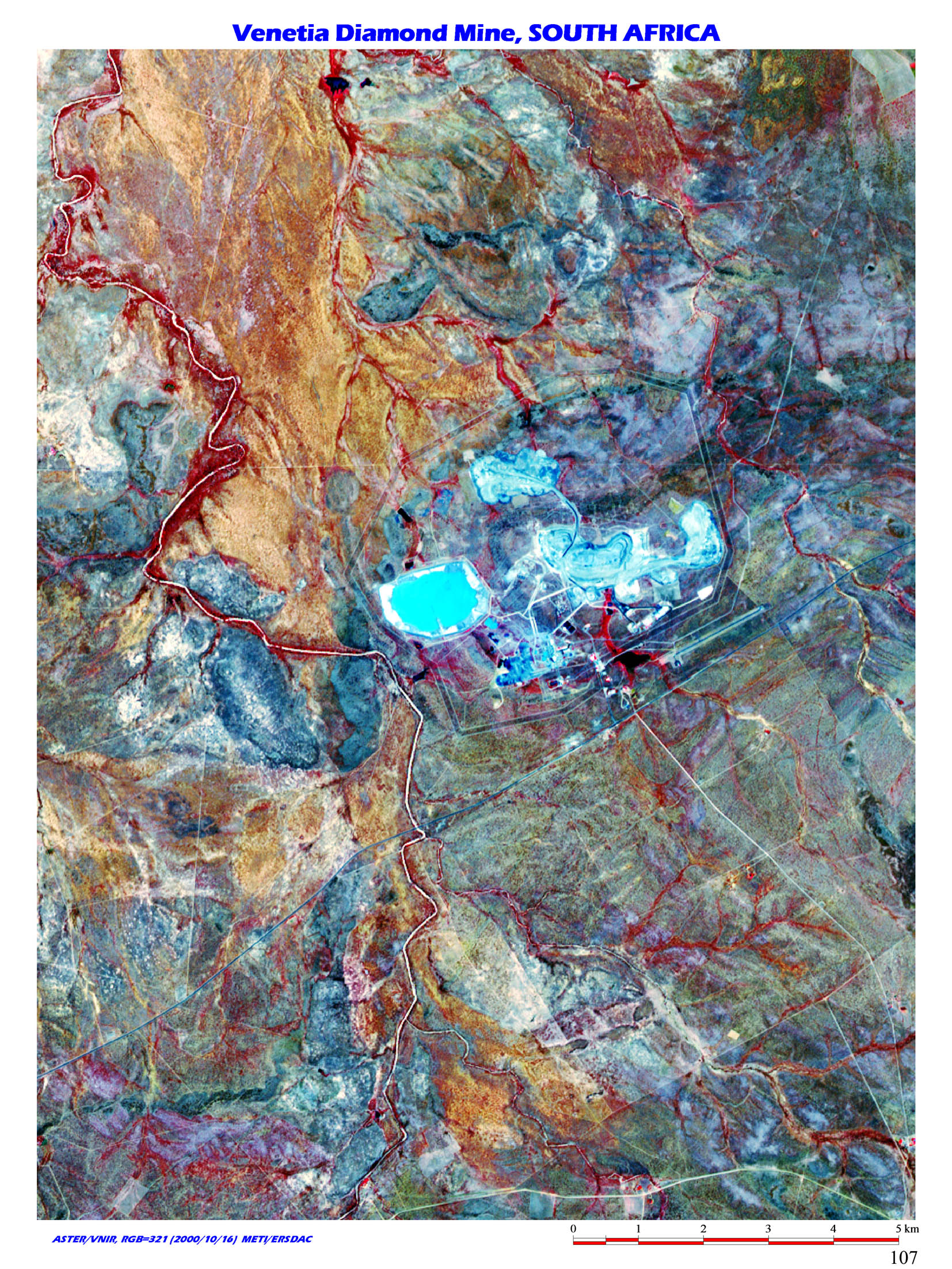 |
50. The largest diamond mine in South Africa, Venetia Diamond Mine, South Africa / (S22 30/E29 20) This is the largest diamond mine in South
Africa, located 80km from Messina, northern South Africa. The world's biggest syndicate De Beers owns the mine. |